(UPDATE: Sept. 4 @ 4:45 pm) – The Lytton Creek wildfire is now classified as under control.
BC Wildfire Service (BCWS) explains that the fire has “received sufficient suppression action to ensure no further spread of the fire.”
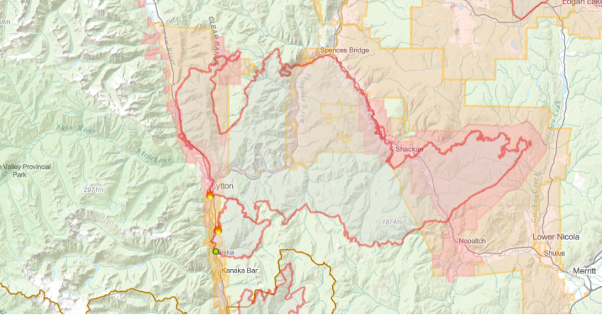
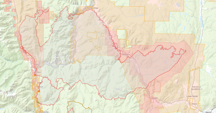
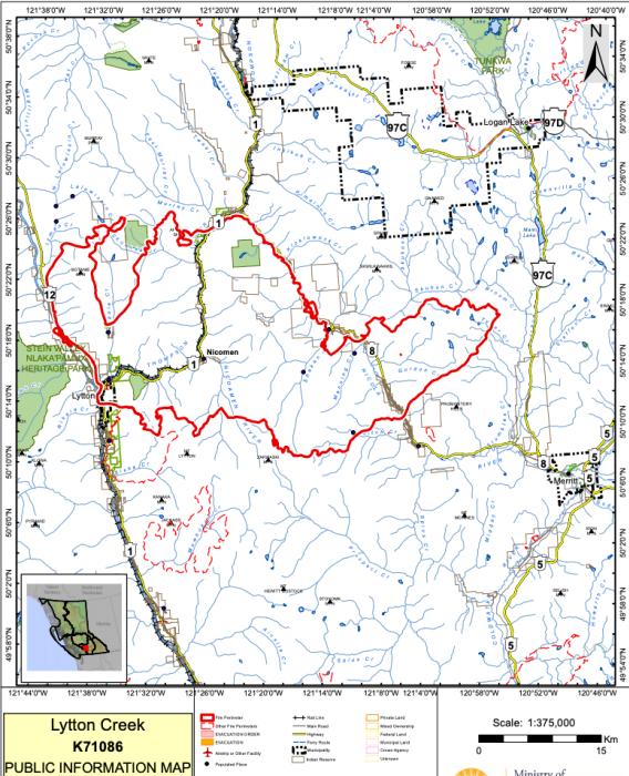
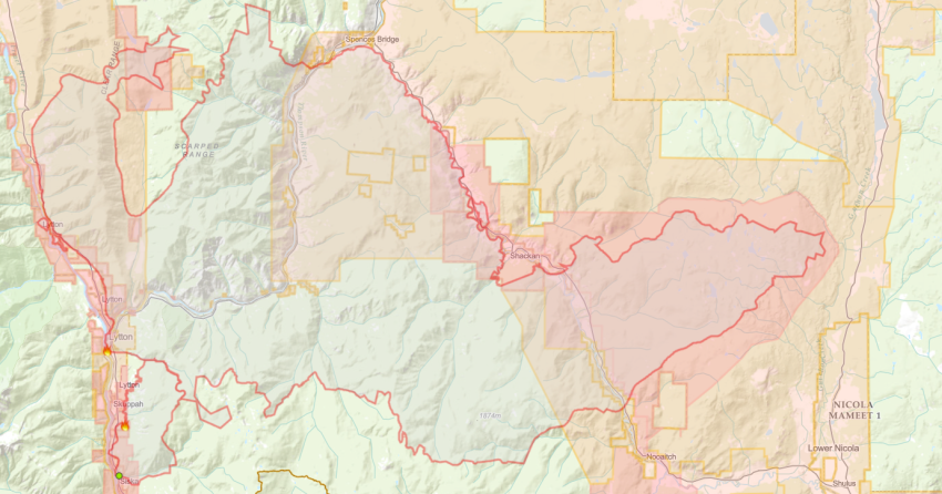
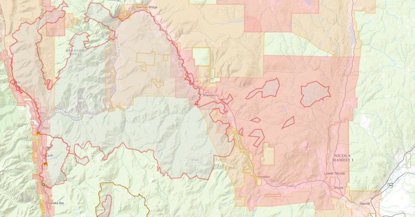
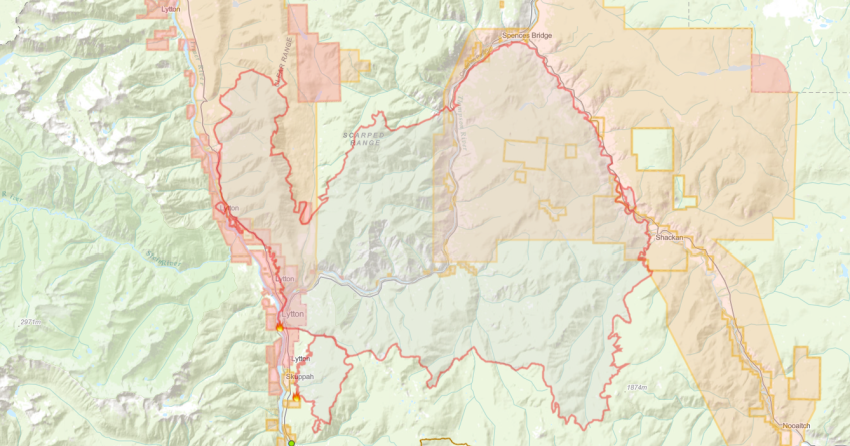
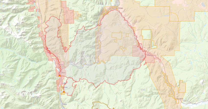
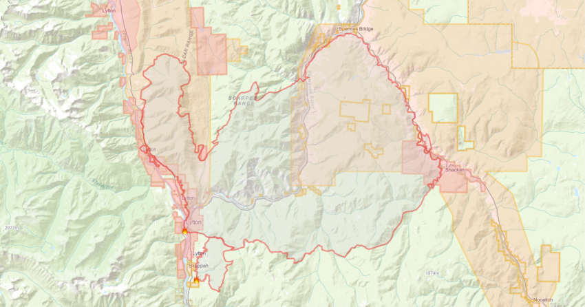
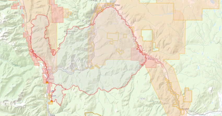
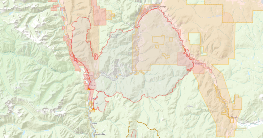
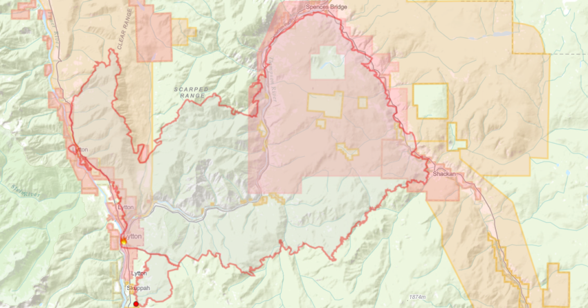
The fire burned an estimated 83,740 hectares since it was discovered on June 30.
The cause remains under investigation.
The Thompson-Nicola Regional District rescinded all evacuation orders and alerts this week based on the recommendations made by BCWS.
There are 69 firefighters, eight pieces of heavy equipment and aerial support available.
Crews will continue to patrol and mop up around the fire’s southern perimeter and along Highway 8.
Equipment that is set up along containment lines within the Botanie Valley is now being demobilized.
Heavy equipment and ground crews will continue to extinguish hotspots and patrol the area.
(UPDATE: Sept. 2 @ 1:16 pm) - No significant growth has been noticed on the Lytton Creek wildfire as crews continue to focus on direct attack, gear retrieval and working with heavy equipment where necessary.
The number of crew members and personnel will decrease as conditions change, and helicopters are only being utilized if needed.
All structure protection equipment has been removed from the Botanie Valley, Onion and Turnip Lakes, Nooaitch and the Sunshine Valley.
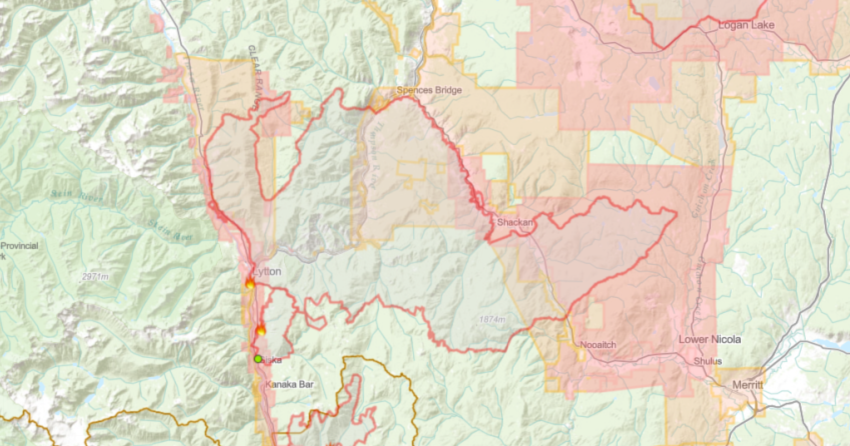
An Area Restriction is in effect within the fire perimeter east of Hwy 8. Access is limited to fire operations and other essential services.
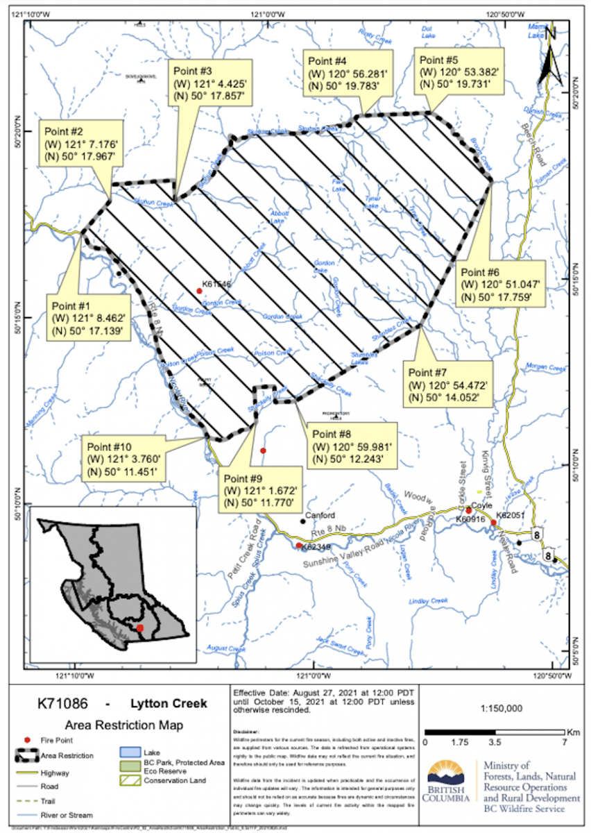
“Please note that an Area Restriction is in effect for this fire and NO hunting is permitted within the area indicated in the attached map. This Restriction is to provide for the safety and security of wildland firefighters,” said BCWS.
All evacuation alerts related to the Lytton Creek wildfire have been rescinded.
There are currently 94 firefighters on scene working alongside 11 pieces of heavy equipment, and two line locators.
(UPDATE: Sept. 1 @ 1:45 pm) – Another 955 TNRD properties in electoral areas I, M and N have been downgraded to all clear.
The downgraded evacuation alerts come as a result of recommendations from BC Wildfire Service that the Lytton Creek wildfire risk is diminishing.
(UPDATE: Sept. 1 @ 12:20 pm) – No significant growth has been observed on the Lytton Creek wildfire for several days.
BC Wildfire Service says that the fire has burned an estimated 84,740 hectares.
The agency forecasts a mainly sunny day with a high of 19ºC and light winds.
There are 106 firefighters, 12 pieces of heavy equipment, two line locators and an incident management team assigned to this fire.
The Thompson-Nicola Regional District rescinded an evacuation alert to all clear for 70 properties north of the Village of Lytton.
Crews are focusing their efforts on direct attack operations while retrieving and demobilizing their gear.
Heavy equipment and helicopters are being utilized where necessary.
The Type one firefighting crews have also been working in areas with difficult terrain and higher fire activity.
Work continues east of Highway 8 to build a fire guard around the entire perimeter of the fire.
A guard has been completed in the southern perimeter of this section.
On the western side of Highway 8 crews are engaging in mop up operations, direct attacks where necessary and patrolling the area.
(UPDATE: Aug. 30 @ 11 am) – BC Wildfire Service (BCWS) confirms that no significant growth or increased fire activity has been observed on the Lytton Creek wildfire.
The fire is estimated at 83,740 hectares and the cause remains under investigation.
The agency is forecasting a cloudy day with cooler temperatures but expects wind to pick up this evening.
There are 115 firefighters, 11 pieces of heavy equipment and two line locators on site.
Crews are supported by the Lytton Creek Complex incident management team which also includes four structure protection personnel and four helicopters.
Work to complete a fire guard east of Highway 8 continues today.
A section of the guard on the southern part of the area has been completed while construction is ongoing on the northern perimeter.
BCWS explains that all structural protection equipment has been demobilized “except for Onion Lake, which should be completed by the end of today.”
Many of the communities in the vicinity of this fire remain on or have been downgraded to evacuation alert.
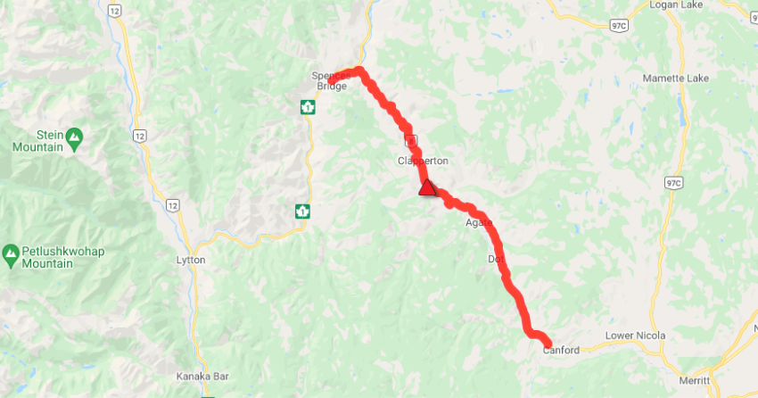
The most recent downgrade was for 22 properties in the Clapperton and Dot Ranch area on Friday, Aug. 27.
Visit tnrd.ca for more information.
(UPDATE: Aug. 29 @ 7 pm) – BC Wildfire Service is reporting that no significant growth has been observed on the Lytton Creek wildfire and it remains estimated at 83,740 hectares.
There are 105 firefighters, 18 pieces of heavy equipment and two line locators on site today.
The cause of this fire remains under investigation and the fire is still classified as out of control.
BCWS forecasts a mainly sunny day with temperatures in the mid to high 20s with moderate winds.
However, the agency notes that the cooler temperatures and higher humidity overnight has helped to keep fire activity low.
Today, danger tree fallers are working ahead of the ground crews to ensure hazardous trees don’t impact their safety.
Ground crews are focusing their efforts on the northwest flank of the fire near the Botanie Valley and along Highway 8.
Structure protection personnel continue to remove equipment in areas that have been downgraded to evacuation alert.
An area restriction was issued on Friday, Aug.27 to protect the public and crews.
There have been no further changes to evacuation notices since the evacuation order for Thompson-Nicola Regional District electoral areas I, M and N was downgraded to an alert on Friday, Aug.27.
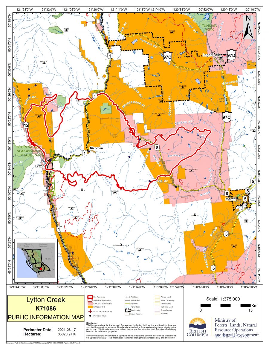
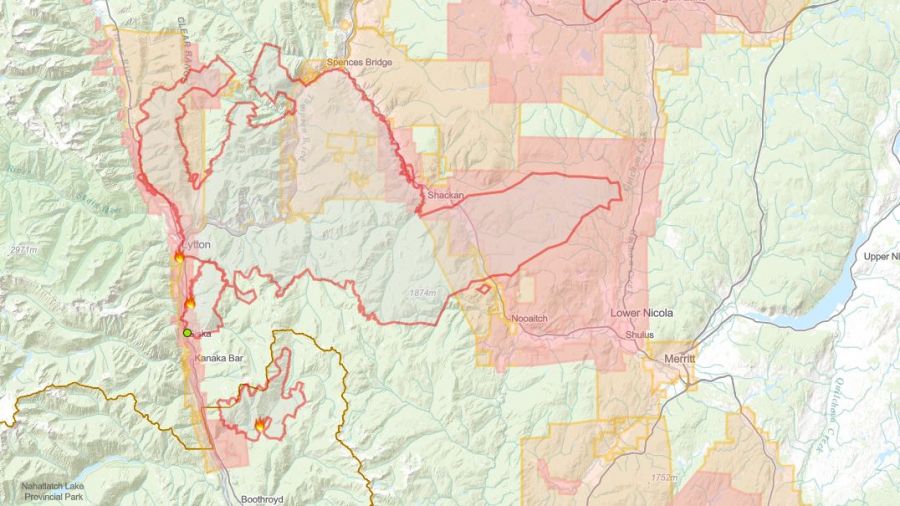
(UPDATE: Aug. 28 @ 6:15 pm) – The Lytton Creek wildfire was remapped at 83,740 hectares.
There are 109 firefighters, 18 pieces of heavy equipment and two line locators assigned to the fire today.
On Friday, Aug.27, BCWS implemented an area restriction for within the fire perimeter east of Highway 8 for the safety of fire crews and the public.
The BCWS update explains that “access is limited to fire operations and other essential services as well as those travelling to or from principal residences.”
Yesterday evening, the Thompson-Nicola Regional District downgraded an evacuation order to an alert for 22 properties in electoral areas I, M and N.
There has been no significant growth recorded on the Lytton Creek wildfire for a number of days.
Helicopters and ground crews continue to extinguish hotspots while construction on fire guards is ongoing.
BCWS confirms that “work is almost complete to contain the entire fire perimeter east of Highway 8 as well as along the south perimeter, west of Highway 8.”
As construction on the fire guards nears completion, BCWS note that operations will move from heavy equipment and air support to Type 1 fire crews.
These types of firefighters are highly skilled and experienced so they can work in areas with high levels of fire activity.
Danger tree assessments and falling is also an ongoing operation that ensures the safety of crews.
(UPDATE: Aug. 27 @ 12:15 pm) - Fire guards are close to being complete for the Lytton Creek wildfire and operations are shifting focus from the use of heavy equipment and air support to additional type one fire crews.
Type one fire crews are highly skilled and experienced firefighters from BCWS and other government agencies, who are trained to work in areas of high fire activity.
The wildfire has not seen any new growth and remains at an estimated 83,876 hectares.
In active fire areas, danger tree assessors and fellers are working ahead of the fire crews, who are moving in to conduct fire suppression on hot spots along the perimeter.
Priority areas include the northwest area near the Botanie Valley and the area east of Hwy 8.
As of last night a few evacuation orders have been downgraded to alerts, that includes the TNRD electoral area I, M, N and areas south Dot Ranch Cut off road, Canford, Sunshine Valley, and Nooaitch.
There are still multiple orders and alerts in the area, check the TNRD website for the most up to date information.
Structure protection crews will be entering communities who are coming off the orders to remove equipment.
As of now there are 90 firefighters, 23 pieces of heavy equipment, and two line locators, including the 14 structure protection teams and five helicopters being shared within the Complex.
(UPDATE: Aug. 26 @ 10:52 am) - No significant growth has been observed at the Lytton Creek wildfire, which remains at an estimated 83,876 hectares.
Overnight a drone crew conducted infrared scanning along the north and south fire perimeters along Hwy 8, cooler temperatures provided a more accurate heat sensor reading to identify hot spots that may not be visible.
Fire crews will now prioritize these areas for a direct attack.
Guards running east of Hwy 8 and west of the 97C have been connected, as crews continue to work with bulldozers and excavators to complete the line.
BC Hydro has also completed pole and line replacement work along Hwy 8.
There are currently 94 firefighters, 27 pieces of heavy equipment, and two line locators assigned to the fire, as well as an incident management team who is handling the Lytton Creek Complex.
There are 16 structure protection teams and five helicopters being shared within the complex.
There are still multiple evacuation orders and alerts issued in the area, it's important to check with TRND for up to date information.
The cause of the fire remains under an investigation.
(UPDATE: Aug. 25 @ 10:40 am) – The Lytton Creek wildfire complex continues to receive cooler temperatures and as a result the fire has been re-estimated at 83,876 hectares.
BC Wildfire Service is forecasting a sunny day with highs in the mid-20s.
Clouds will move in this afternoon with the potential for wind gusts, however, with the recent rain no fire activity is expected.
Last night, the Ministry of Transportation opened Highway 12 from Lytton to Lillooet.
The Lytton First Nation closed the road that was being used as a detour through their reserve so the community can come together to perform ceremonies and grieve the loss from the wildfire.
Although the road is safe to travel, motorists are advised to keep their windows rolled up and must not stop for the three kilometres through the Village of Lytton on June 30.
The highway has been closed since July when the Lytton Creek wildfire moved through the village.
RCMP and local highway contractors will continue to patrol the area for safety and security of residents and motorists.
There are 105 firefighters, 28 pieces of heavy equipment and two line locators on scene today.
According to BCWS “plans are underway for a drone crew to conduct infrared scanning within the north and south fire perimeter along Highway 8.”
The scan will identify hotspots which ground crews can directly attack and extinguish.
Crews continue to work in collaboration with the Lower Nicola Indian Band to secure Highway 8.
The guard that runs east from Highway 8 to Highway 97C is now complete.
Work will be ongoing to mop up the area and reinforce the containment line.
An evacuation alert for 656 properties in TNRD electoral areas “I,” “M” and “N” remains in effect.
An evacuation alert for 51 properties and 111 properties in another portion of TNRD electoral areas “M” and “N” is also in place.
Visit tnrd.ca for more information.
(UPDATE: Aug. 24 @ 6:00 pm) – BC Wildfire Service explains that no significant activity has been observed on the fire.
However, it continues to burn out of control at 84,536 hectares.
Despite the size of the fire, the fire received around four to 12mm of rain yesterday and temperatures dropped to between three and five degrees.
There are 78 firefighters and 34 pieces of heavy equipment on site.
The objectives of fighting this fire are focused on securing Highway 8 through collaboration with the Lower Nicola Indian Band.
“Heavy equipment work on the fire guard along the southern edge of the fire is progressing well.”
The guard runs from Highway 8 east towards Highway 97C and is expected to be completed today.
BC Hydro is working in the area to replace hydro poles that were impacted by the fire.
BCWS crews are also working to contain the fire’s northeast flank with a guard and widened forest service road.
Since a minor change in evacuation orders happened on Friday, Aug.20, no other changes have occurred.
(UPDATE: Aug. 23 @ 12:40 pm) – The Lytton Creek Complex received varying amounts of rain overnight from three to 23mm and low temperatures.
The Lytton Creek wildfire is now estimated at 84,536 hectares – down from the 84,825 hectares recorded over the weekend.
BC Wildfire Service is not expecting any significant wildfire activity today.
There are 48 firefighters, 33 pieces of heavy equipment and four helicopters on scene.
Helicopters will continue to bucket water onto hotspots within the main body of the fire.
Crews are also working to secure and further reinforce the fire guard from Highway 8 moving westwards.
However, BCWS explains that “The guard running from Highway 8 to Highway 97C are expected to connect in the next day or two.”
Progress on the guard being established near the southern flank was slowed on Sunday, Aug. 22 due to rain.
Crews are working in collaboration with the Lower Nicola Indian Band on this guard.
Today’s BCWS update finished by explaining that in areas where evacuation notices have been rescinded, structural protection crews may still need access to properties so they can remove equipment.
Since the evacuation order was changed to an alert for TNRD electoral areas “I”, “M” and “N” on Friday, Aug. 20, there have been no other changes to existing evacuation notices.
(UPDATE: Aug.21 @ 4:45pm) – Today, BC Wildfire Service is estimating the Lytton Creek wildfire at 84,825 hectares.
There are 40 firefighters, 33 pieces of heavy equipment and four helicopters assigned to the fire today.
BCWS is forecasting moderate temperatures for the area with the potential for gusting winds and showers this afternoon.
Crews will be monitoring the eastern flank of the fire for increased activity today due to a lack of rain in this area.
However, significant rainfall was observed in the northern flank of the fire, near Spences Bridge, which helped suppression efforts.
Crews completed fire guards in the north and will work to lay hose along Highway 8 towards the eastern flank of the fire.
BCWS explains that crews have completed “structure protection work [...] in Nooaitch and continues south along the Highway 8 corridor.”
Patrolling, monitoring and mop up operations are ongoing.
The City of Merritt has rescinded the evacuation alert, effective Saturday, Aug. 21 at noon.
There have been no changes to the evacuation orders or alerts issued by the Thompson-Nicola Regional District.
(UPDATE: Aug.20 @ 2:05 pm) - Fire activity has been low for the Lytton Creek wildfire as no new growth has been noted for the 84,327 hectare fire.
Crews have made significant progress on the fire guard along the south and southeast flanks of the fire between Hwy 8 and 97C. Guard work also began to the west of Hwy 8, work will continue in the coming days to protect the highway's and communities to the southeast.
Helicopters continue to bucket on hot spots and additional heavy machinery will be moved as they become available, containment plans for the north, east, and south are in the works.
There are currently 44 firefighters, 29 pieces of heavy equipment, and 11 helicopters assigned to the Lytton Creek wildfire.
An Incident Management Team is currently in charge of the Lytton Creek Complex, 28 Structure Protection Personnel and 13 helicopters fires are being shared within the complex.
The evacuation orders issued for Electoral "I", "M", and "N", by the TRND has now been downgraded to an alert, this allows for 656 properties to return home.
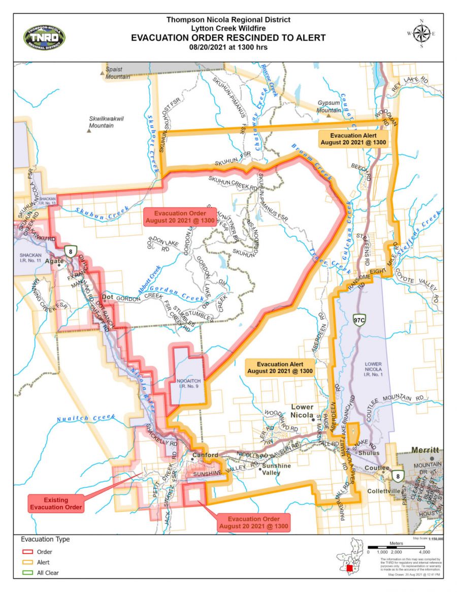 Evacuation orders remain in place still for the following properties attached in the map.
Today, the fire can expect relatively cool temperatures and a slight chance of showers or thunderstorm.
(UPDATE: Aug. 19 @ 12:01 pm) - There has been no new significant growth seen for the Lytton Creek wildfire overnight, but warm and dry conditions continue to ramp up fire behaviour.
The fire is still estimated to be around 84,327 hectares but activity for the fire is anticipated to increase as fuels are drying quickly in the area.
Yesterday BCWS was focused on the southeastern, southwestern, and northeastern flanks of the fire and helicopters actioned hotspots in those areas while ground crews continued to build guards.
 The fire on the southwestern side remains approximately 3 km west of Hwy 97 C.
This afternoon crews will be directing their attacks on hot spots on the east side of the fire and helicopters will continue to bucket in the area, as heavy machinery will build guard lines along the Hwy.
Multiple road closures due to the fires and mudslides have created challenges for the movement of crews over the last two days
There are currently 51 firefighters, 34 pieces of heavy equipment, and 11 helicopters assigned to the wildfire.
An Incident Management Team remains in place for the Lytton Creek Complex with 28 Structure Protection Personnel and 13 helicopters shared within the Complex.
Rain is expected for the weekend, and crews are relying on the cooler temperatures to help aid in fighting the fire.
Multiple evacuation orders and alerts ordered by Thompson-Nicola Regional District remain in place.
(UPDATE: Aug. 18 @ 12:40 pm) – The Lytton Creek wildfire has been showing an increased amount of fire activity this week.
The fire is now estimated to be burning at 84,327 hectares.
Although the fire received rain, ranging from 18mm to 38mm, the Lytton Complex continues to experience dry and windy conditions – and BCWS is expecting these conditions to increase this week.
“The cool, wet weather limited fire activity in the fine fuels but these are expected to dry out again and become more active by Wednesday or Thursday afternoon,” the agency explains.
There are 108 firefighters, 24 pieces of heavy equipment and 11 helicopters assigned to the fire today.
BCWS confirms that the fire continues to burn 3km away from Highway 97C where crews continue to build a guard on the southeastern flank.
“This work will continue for several days to protect the highway and communities to the southeast.”
Today, structural protection personnel will head to the community of Nooaitch and infrastructure along Highway 97C will be assessed.
The agency confirms that danger trees assessment and falling will commence today along Highway 8, to ensure the safety of crews and other emergency responders.
DriveBC reports that Highway 8 remains closed from 3km west of Merritt to 15km east of Spences Bridge.
The mudslides that occurred on Highway 1, between Cache Creek and Lytton, continue to challenge the crews’ ability to move around the fire.
The City of Merritt remains on evacuation alert.
Visit tnrd.ca for more information on evacuation orders and alerts issued by the Thompson-Nicola Regional District.
(UPDATE: Aug. 17 @ 12:55 pm) - The Lytton Creek wildfire continues to exhibit significant growth at a troublesome rate.
The fire is now mapped at 71,323 hectares, which is 15,000 hectares larger than the size estimate on Monday.
After destroying the Village of Lytton on the day it sparked seven weeks ago, the fire has turned its sights on the City of Merritt in recent days.
Fortunately, the most recent fire map from the BC Wildfire Service shows that the easternmost flank of the fire appears to be moving in a direction north of Merritt.
On that eastern flank, crews continue to extinguish hot spots to the south and will be looking to conduct danger tree assessment and falling along Hwy 8 if it's safe to do so, which includes cleaning up downed power lines with BC Hydro.
"Direct attack measures will continue along Hwy 8 to make the road safe for emergency responders and to protect structures in the area," explained the BCWS.
To the west, mudslides along Hwy 1 between Cache Creek and Lytton have created challenges for crew movement.
Despite that, they are continuing suppression activities in areas that require is and work is expected to be completed today on a fire guard in the Izmen Creek area.
The City of Merritt remains under evacuation alert, while the Thompson-Nicola Regional District has a number of other evacuation alerts and order in place due to this fire.
There are currently 87 firefighters, 24 pieces of heavy equipment and 11 helicopters assigned to this fire, along with structure protection personnel.
(UPDATE: Aug. 16 @ 3:40 pm) – The Lytton Creek wildfire has grown to 56,329 hectares.
There are 89 firefighters, 11 helicopters and 24 pieces of heavy equipment on site.
Crews are supported by an incident management team from the Lytton Creek Complex, which also includes 28 structure protection personnel and 13 helicopters.
BC Wildfire Service explains that “fire growth, fuelled by hot and dry conditions and strong winds, has continued east of Highway 8 and the Nicola River.”
The agency reports that the fire is burning approximately 4km away from Highway 97C with high amounts of smoke visible.
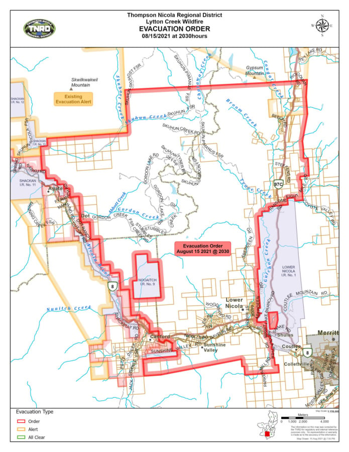
The City of Merritt issued an evacuation alert for the entire city, effective Aug.15 at 7:50 pm
The evacuation alert is in response to the heightened behaviour of the Lytton Creek wildfire.

The Thompson-Nicola Regional District issued an evacuation alert for 51 properties in the Sunshine Valley East area, effective Aug.15 at 9:47 pm.
Those properties include:
-
600 to 660 Billwiller Rd
-
68 to 380 Coldwater Rd
-
81 to 507 Lindley Creek Rd
-
465 to 1119 Merritt-Spences Bridge Hwy 8
-
181 to 818 Midday Valley Rd
-
700 to 840 Neilson St
-
88 to 304 Veale Rd
The TNRD also issued an evacuation order for 656 properties in the electoral areas “m” and “n” (Beautiful Nicola Valley), effective Aug. 15 at 8:50 pm.
Visit the TNRD website for the latest updates to evacuation notices due to the Lytton Creek wildfire.
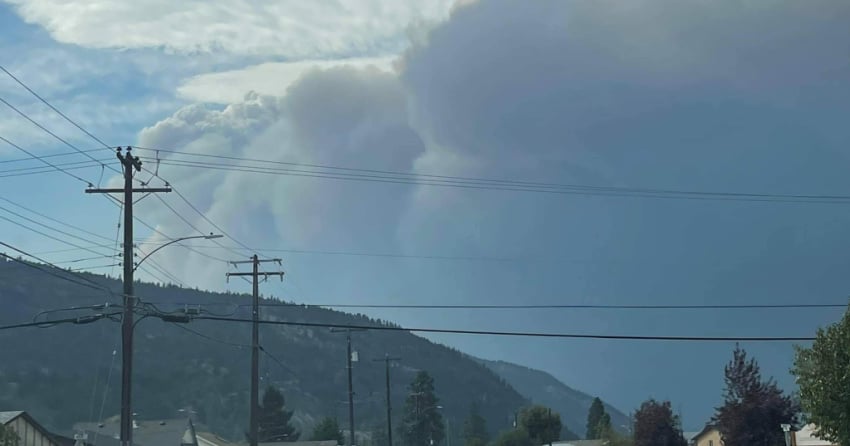
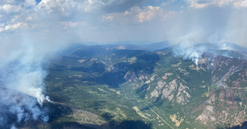
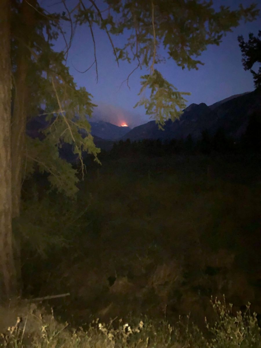
The northern flank of the fire near the Botanie Valley has also experienced “extreme” fire behaviour.
Today, air resources worked to extinguish the hotspots in the area.
Sunday afternoon, BCWS reports that the fire was moving east and a few hotspots had crossed Highway 8 and the Nicola River.
“Helicopters have been bucketing since the morning and continue where possible. This fire behaviour is due to hot and dry weather.”
The cause of this fire, which was discovered on June 30, remains under investigation.
(UPDATE: Aug. 14 @ 8:30 pm) – The Lytton Creek fire has experienced some significant growth in the past two days.
BC Wildfire Service (BCWS) is now estimating that this fire is burning at 54,395 hectares – a growth of 2,619 hectares since Thursday.
There are 77 firefighters, seven helicopters and 28 pieces of heavy equipment working on this fire today.
BCWS explains that increased fire activity was experienced on site today, and much of the same is expected for tomorrow.
“Fire behaviour is due to the extreme drought conditions and the current hot and dry weather. This activity is not due to ignition operations,” explains that agency.
Strong winds were reported today, accompanied by an increase in smoke which made it difficult for air resources to partake in suppression efforts.
BCWS explains that crews on the eastern flank observed a spot fire that had crossed a containment line two days ago (in the Manning Creek area).
Air resources were quick to suppress the fire and ground crews continued mop up activities and reinforcing the containment lines today.
Crews working on the western flank monitored, patrolled and mopped up hotspots near the Botanie Valley.
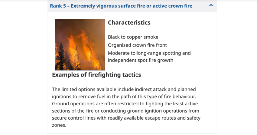
Yesterday, Aug. 13, crews observed an increase in ground fires and even some torching of trees – BCWS explains there is a potential for rank five fire activity in this area.
Visit the Thompson-Nicola Regional District website for more information on current evacuation notices.
The TNRD evacuation status map is also a resourceful place for information.
(UPDATE: August 12 @ 3:40 pm) - The Lytton Creek wildfire remains at an estimated 51,766 hectares, but fire behaviour has increased in the Platt Creek area in the south end of the fire perimeter.
While the fire has been quiet for the past few days, the increase in behaviour is due to the extreme drought conditions that have been present throughout summer, as well as the current hot and dry weather.
Smoke became highly visible yesterday in communities such as Nooaitch and Hwy 8 south of Agate.
The fire is currently ranked at a level six in behaviour, but does not pose an immediate risk to communities near by.
There are currently 81 firefighters, 29 pieces of heavy equipment, 28 Structure Protection Personnel, and seven helicopters being shared between the Lytton Creek Complex.
Heavy equipment continues to widen the Laluwissin and Izmen FSRs, north of the fire, and crews are monitoring the west side of the fire along the Fraser River as well as power lines in the area.
The BC Wildfire Service is frequently assessing recommendations regarding evacuation alerts and orders for the regional districts.
You can see which properties have been affected by going to the TNRD website.
(UPDATE: Aug. 10 @ 2:20 pm) – Fire activity at the Lytton Creek wildfire has remained low and minimal.
The fire continues to burn at an estimated 51,766 hectares.
BC Wildfire Service is expecting warmer and dried conditions through the week.
“A wind shift is expected tonight with winds coming out of the north,” reports the agency.
Today, there are 82 firefighters, seven helicopters and 32 pieces of heavy equipment on site.
They are supported by 28 structure protection personnel.
Crews were successful with planned ignition operations in the Shackan Valley from Shackan Creek to nearby power lines.
Structure protection personnel patrolled Shackan during these operations to ensure embers didn’t affect the community.
The planned ignitions will prevent any excursions from happening in the eastern flank.
In the western flank, crews continue with their mop up activities in the Botanie Valley.
Structure protection personnel continue to “deploy, test and maintain equipment in the Turnip and Onion Lake areas.”
Visit this link for all the latest updates on evacuation notices for the Lytton Creek wildfire.
This evacuation notice map is also a resourceful piece of information.
(UPDATE: Aug. 8 @ 5:15 pm) – The Lytton Creek wildfire has grown approximately 440 hectares since Thursday.
It is now estimated at 51,776 hectares.
Today there are 83 firefighters, seven helicopters and 36 pieces of heavy equipment on site.
BC Wildfire Service (BCWS) is anticipating low, or rank one, fire behaviour today.
“Approximately 5 millilitres of precipitation accumulated on the Lytton Creek wildfire overnight.”
The rain and cooler temperatures resulted in minimal fire growth.
On Friday, Aug. 6 the Thompson-Nicola Regional District issued an evacuation order for 6 properties in the electoral area “I” (Blue Sky Country).
Visit this link for updates on evacuation notices from the TNRD.
Crews working on the eastern flank stayed on site overnight but were unable to perform their planned ignitions due to unfavourable conditions.
They will continue to mop up hotspots and work to remove available fuel in the area.
“Crews were able to hold the southeast corner with support from helicopters bucketing, despite strong up valley winds and were able to make progress with mop up in this area,” notes BCWS.
Control lines have been established north of Agate, guards are being connected in the Manning Creek and Nuaitch Creek areas.
On the western flank, smoke was visible throughout the day from the Botanie Valley while crews patrolled the area and tested structural protection equipment.
Crews will continue with mop up operations in this area.
(UPDATE: Aug. 5 @ 4:40 pm) – The Lytton Creek wildfire has shown steady growth this week and is now burning at an estimated 51,336 hectares.
Today, there are 74 firefighters, six helicopters and 34 pieces of heavy equipment on site.
Yesterday, crews were unable to engage in their planned ignitions due to unfavourable conditions (and the same happened on Wednesday).
Crews started work later today so they can work during the night once again.
BC Wildfire Service reports that a guard was completed on the southeast flank near Shackan.
A control line has been built north of Agate and another guard is being built north of Nuaitch Creek.
Structure protection equipment has been sent to Shackan and the Nooaitch community will be assessed.
Crews continue to mop up hot spots along Highway 8 and near the communities of Nicomen and Gladwin.
Visit this link for all the latest updates for evacuation orders and alerts issued by the Thompson-Nicola Regional District.
(UPDATE: Aug. 4 @ 5:20 pm) – The Lytton Creek fire grew about 79 hectares overnight and is now burning at 51,289 hectares.
There are 47 firefighters, six helicopters and 34 pieces of heavy equipment working on this fire.
The heavy equipment crews completed a fire guard near the community of Shackan.
More guards will be built north of Agate and Nuaitch Creek.
Those guards will be connected to roads and creeks in the area to utilize natural fuel breaks.
Yesterday, crews were unable to engage in controlled hand ignitions due to unfavourable weather conditions.
Crews stayed on scene overnight to execute their operations.
BCWS reports that structure protection equipment is being demobilized from Spence’s Bridge and Cook’s Ferry Indian Band thanks to the precipitation and reduced fire activity in those areas.
The communities of Shackan and Nooaaitch are now being assessed for structure protection and equipment will be sent to areas that need it.
Crews worked on mop up operations along the highway 8 corridor and the areas around Nicomen and Gladwin.
To learn more about the evacuation orders and alerts that were issued by the TNRD, visit this link.
(UPDATE: Aug. 3 @ 12:25 pm) - More than a month after destroying the Village of Lytton in a single evening, the Lytton Creek wildfire continues to burn out of control.
It grew around 8,000 hectares over the long weekend and is now estimated at 51,210 hectares in size.
Evacuation orders and alerts remain in place through the Thompson-Nicola Regional District, which you can learn more about here.
Despite the growth, the BC Wildfire Service said that the precipitation has helped reduce fire activity in recent days.
Heavy equipment and ground crews continue to construct guards on the southeast flank that will be connected to existing roads and creeks that serve as natural fuel breaks.
The main goal for crews today, if conditions allowed for it, was to conduct planned ignitions in that area.
"Ignition operations will bring the edge of the fire to an area that is workable by ground crews," explained the BCWS.
"A combination of aerial and hand ignitions may continue over the next few days if conditions allow."
There are currently 47 firefighters, 34 pieces of heavy equipment and six helicopters assigned to this blaze, which is under the watch of a BCWS incident management team.
(UPDATE: July 29 @ 9:20 am) – There are 91 firefighters, 6 helicopters and 31 pieces of heavy equipment fighting this fire.
Crews were successful in controlled ignitions which has resulted in limited fire growth in the area surrounding Spences Bridge.
“There was increased fire activity on the west side of the Thompson River and Highway 1 yesterday,” explains BC Wildfire Service.
The agency goes on to affirm that no structures were in immediate danger while crews monitored the fire overnight.
BCWS explains that structural protection equipment has been established “along the Nicola River from Shackan Indian band to Spences Bridge.”
Significant smoke in the area is due to an increase in fire activity on the west side of the Botanie Valley.
BCWS explains that there is potential for more growth on this fire which is dependent on weather, topography and available forest fuels.
The TNRD evacuation order for 169 properties in the Spences Bridge electoral area “I” (Blue Sky country) remains in place.
The evacuation alerts for the Pimainus Lake area in electoral area “I” (BLue Sky Country) also remain in place.
Visit DriveBC for updates on Highway 8.
(UPDATE: July 27 @ 9:40) – The Lytton Creek wildfire grew 4,496 hectares since Sunday.
Smoky conditions have made it difficult to estimate the fire perimeter and new mapping puts it at 37,452 hectares.
Last night, there was increased activity near Highway 1 and crews worked on the fire spots close to the highway.
Crews were successful in their controlled ignitions and initial attacks on the fire overnight.
The fire saw significant growth in the southeast flank of the fire where the terrain is steep and difficult for crews to work in.
Helicopter crews continue to work in the north flank of the fire where there is also steep and rocky terrain.
DriveBC reported that Highway 8 conditions are changing quite frequently as the fire is burning close by. The latest update came in before 9 am this morning:
“Highway 8, in both directions. There is a wildfire between the start of Highway 8 and Petit Creek Rd for 46.3 km (Spences Bridge to 17 km west of Merritt). Road closed. Assessment in progress.”
There are 66 firefighters, four helicopters and 28 pieces of heavy equipment working on this fire.
The area restriction for the Lytton Creek Complex was rescinded by BCWS as of July 22.
Evacuation orders and alerts for the are remain in place, visit Thompson-Nicola Regional District for more information.
(UPDATE: July 25 @ 7 pm) - The Lytton Creek wildfire experienced solid growth over the weekend.
According to the BCWS, the blaze is now sitting at 32,957 hectares. It is still classified as out of control.
"Wildfire activity continues to be expected to increase in the afternoons in some sections of the fire as hot and dry conditions persist, as well as strong afternoon winds."
"Smoke has occasionally posed visibility challenges. This can impact the ability to get updated tracks for fire perimeters and maps. Updates will be posted as visibility and fire activity allow."
Hwy 8 remains closed due to fire suppression. Evacuation orders are still in effect in the area.
NowMedia will update the story when more information is available.
(UPDATE: July 23 @ 3:40 pm) - The Lytton Creek wildfire remains at an estimated 24,365 hectares, as BCWS says that smoke has made it difficult to update fire perimeters and maps.
Over the last two days the fire has seen significant growth moving northwards.
Since June 30, highways surrounding the area have been closed due to the wildfire and to support firefighting operations. As of today Hwy 1 has reopened between Lytton and Spences Bridge, and Hwy 12 between Lytton and Lillooet.
Travellers can expect closures on short notice should fire activity increase or if suppression efforts are required.
On July 22, crews working in the area were mopping up an escape on the northeast corner of the fire, and had begun constructing guard around it. The escape occurred in high elevation where the fire continues to burn.
An escape is a term used to describe a fire that has breached the control line and remains out of control following an initial attack.
During the day, crews and structure protection personnel were successful in protecting cultural values in the area, but by evening the fire had crested the ridge and slowly moved down slope towards Clapperton area.
Today crews will patrol the escape and set up a water delivery system while working to keep the fire from progressing down the slope. They will also assess the possibility of small scale planned ignitions to bring the fire down to an old rail system that crews can open up to use as guard.
Structure protection has assessed Spences Bridge, Clapperton and Cooks Ferry Indian Band and have begun installing apparatus throughout the community and on critical infrastructure.
An evacuation order still remains in place for the Village of Lytton, Spence's Bridge, and Electoral Area "I".
The Thompson-Nicola Regional District (TNRD) has downgraded the evacuation order for the Gladwin and Jade Springs area to an alert.
The Lytton Creek Complex which includes the Tremont Creek fire will be turned over to a new Incident Management Team (IMT) by end of day.
(UPDATE: July 22 @ 3:40 pm) – The Lytton Creek wildfire has now grown to an estimated 24,365 hectares and remains to burn out of control.
BC Wildfire Service explains that there were strong winds in the area that caused the fire to grow dramatically.
The extreme fire behaviour has prompted the Thompson-Nicola Regional District to move the alert to an evacuation order for Electoral Area “I” (Blue Sky Country) in the vicinity of Spences Bridge.
An evacuation alert remains in place for the remaining portion of Electoral Area “I” (Blue Sky Country) and Electoral Area “N” (Beautiful Nicola Valley-South).
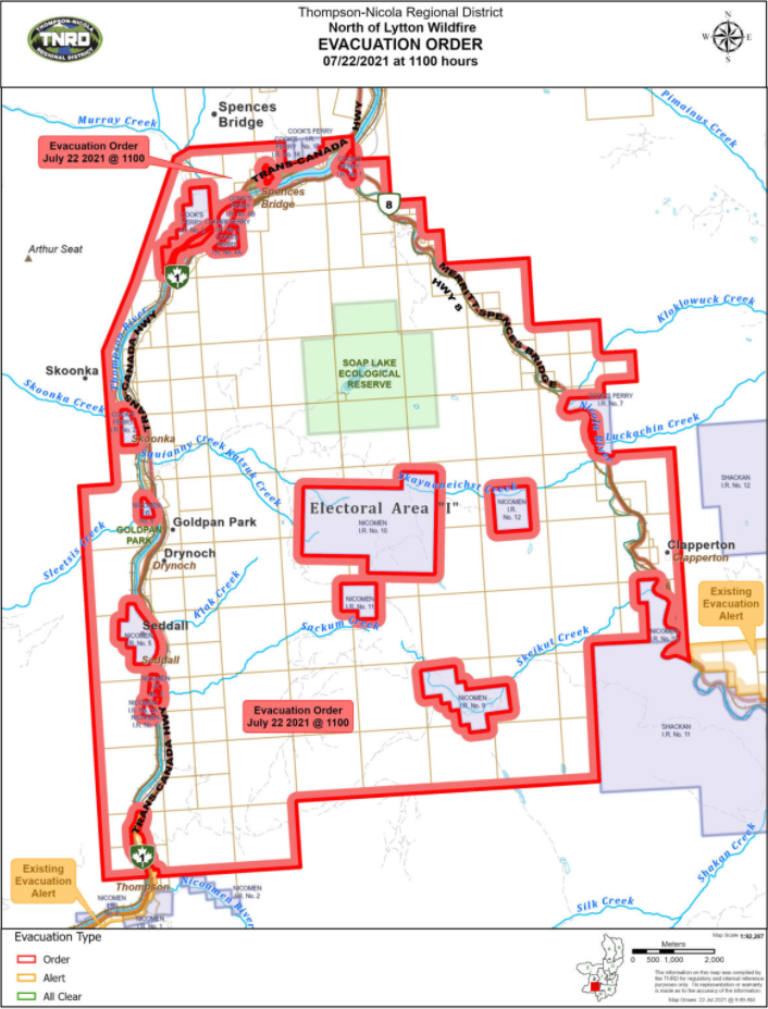
For more information, visit the Thompson-Nicola Regional District website.
This morning there were 42 firefighters, four helicopters and 11 pieces of heavy equipment fighting this fire.
There were 10 BCWS personnel on scene throughout the night.
Crews were assisted by 28 Structure Protection personnel.
The cause of this fire remains to be under investigation.
(UPDATE: July 21 @ 4:30pm): The Lytton Creek wildfire has grown to an estimated 15,664.0 hectares over the past few days.
An evacuation alert issued by the Thompson-Nicola Regional District (TNRD) remains in place for 175 properties in Electoral Area "I" (Blue Sky Country) in the vicinity of Spences Bridge.
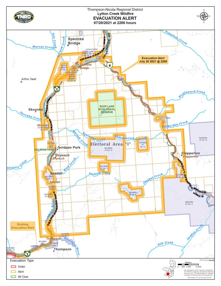 There are 32 firefighters accompanied by five helicopters, and 11 pieces of heavy equipment, aiding to the entire Lytton Creek Complex, which includes the George Road wildfire, the Tremont Creek wildfire, and the Mowhokam Creek fire.
As well there are 28 Structure Protection personnel assigned specifically to the Lytton Creek wildfire.
Yesterday crews secured the burn line from the previous evening and today crews will be line locating and assessing control line options for forward planning as far as the Soap Lake area.
The fires cause is yet to be determined, and still remains under investigation.
(UPDATE: July 19 @ 11:40 am): Over the weekend the Lytton Creek wildfire remains at an estimated 11,060 hectares.
BC Wildfire Service (BCWS) said they are expecting an increase of activity in some parts of the fire this afternoon as dry conditions are resulting in the ignition of un-burnt fuels that lie within the perimeter.
There is no precipitation seen in the short-term forecast, and smoke will continue to be visible in the surrounding area.
In the latest update from BCWS there are currently 31 firefighters, five helicopters, and 20 pieces of heavy equipment.
Resources are being shared with neighbouring fires including the George Road wildfire, the Tremont Creek wildfire and the Mowhokam Creek wildfire.
There are currently 28 structure protection personnel assigned specifically to the Lytton Creek wildfire.
The cause for the wildfire is still under investigation.
(UPDATE: July 16 @ 1:22 pm): The Lytton Creek wildfire has grown to 11,060 hectares.
BC Wildfire Service (BCWS) said despite temperatures "cooling slightly" as the week comes to a close, "hot and dry conditions persist."
Vitally, no rain is forecast.
BCWS added: "Fire growth and activity continues to be heavily influenced by strong afternoon winds."
The agency also warned of smoke emanating from the fire, which could continue to be visible from surrounding areas.
Click here to check the latest evacuation information.
In its latest update, BCWS said there are 69 firefighters, four helicopters and 13 pieces of heavy equipment working on the fire.
The Lytton Creek fire is now part of the Lytton Creek Complex, which includes the George Road wildfire and the Tremont Creek blaze.
No cause has yet been found.
Earlier today, Premier John Horgan said there would be few advantages to declaring a provincial state of emergency in the battle against wildfires as the province is using all of its available resources to fight them.
Opposition politicians and the Thompson−Nicola Regional District, parts of which are under evacuation orders or alerts, have urged Horgan to declare an emergency.
"If there was a state of emergency called today, it would have no impact on resources because they are already in place," Horgan said at a news conference. "We’re putting all hands on deck and the state of emergency is not required to do that."
Firefighters from Quebec and Mexico are en route to assist with local efforts, Horgan added.
More than 300 wildfires were burning in the province on Friday, affecting about 1,500 properties where residents were ordered to leave earlier this week and evacuation alerts remained in effect for many more, including the entire communities of 100 Mile House, Ashcroft and Cache Creek.
Horgan said he would declare a state of emergency only when told to by firefighters and Emergency Management BC.
Brendan Ralfs of Emergency Management BC told a media briefing on Thursday that a state of emergency would change little in the firefighting effort.
"During this current event, a provincial declaration of state of emergency has not been necessary to provide assistance to people, to access funding, or to co−ordinate or obtain additional resources," he said, adding one would be called if it was required.
Environment Canada says heat warnings for parts of the central and southern Interior have ended but wildfire smoke means air quality advisories were posted for most of the eastern half of BC, with conditions not expected to improve through the weekend.
Some parts of the Interior could see showers, but the weather office says any rain in the wildfire−ringed area of 100 Mile House over the next 24 hours could be accompanied by lightning.
About 69% of the active fires listed by the BC Wildfire Service on Friday were believed to have been started by lightning.
– With files from Canadian Press
(Original story: July 13 @ 7:55 am): The Lytton Creek wildfire is expected to grow as the province experiences another heat wave.
BC Wildfire Service (BCWS) said yesterday that the fire is at 8,800 hectares.
“Wildfire activity is expected to continue to increase in some parts of the fire as dry, hot conditions move into the area,” the agency explained.
“There is no precipitation in the short-term forecast. Monday and Tuesday will be the hottest days, after which temperatures are expected to cool a few degrees C.”
On Sunday, BCWS said there was a low chance of the fire progressing any further east.
It remains out of control.
The cause of the disastrous blaze, which levelled the village of Lytton and left two people dead, is still under investigation – though police said yesterday “significant progress” had been made in the search for answers.
BCWS said in its latest update that 150 firefighters are battling the fire, alongside six helicopters and 11 pieces of heavy equipment.


