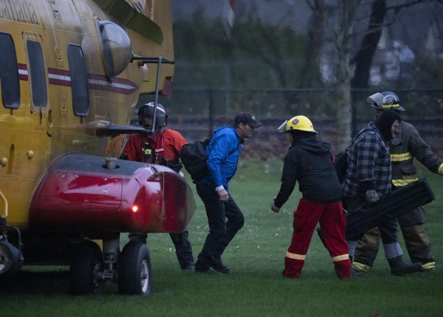
(UPDATE: Nov. 16 @ 5:06 am): Rescue crews will spend Tuesday searching for people who may have been trapped in debris from mudslides on a British Columbia highway, after helicopters worked to ferry out 275 people from a slide site on Hwy 7.
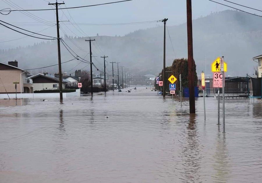
The mudslides rolled over the highway during an "atmospheric river" that brought a deluge of rain and flooding to the southwest and central parts of the province.
The torrential rain closed highways, overwhelmed rivers and creeks and caused the wastewater treatment plant in Merritt to break down, forcing the evacuation of the city of 7,000.
More than 20 emergency centres have been activated to help house stranded travellers.
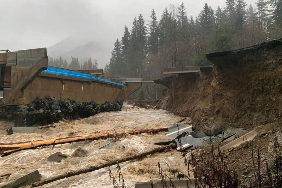
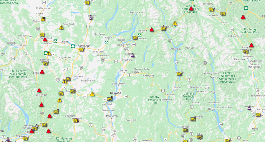
Multiple roadways have been closed because of flooding or landslides, including sections of Highway 1A, Highway 3, Highway 11, Highway 12, and Highway 91.
In a statement posted on Twitter, Prime Minister Justin Trudeau said the federal government is ready to help British Columbians affected by flooding and extreme weather, urging people to stay safe.
There have been no reports of any fatalities.
Meanwhile, stories from individuals caught up in the catastrophic weather are starting to be told.
Melanie Forsythe’s drive home from Vancouver to Hope had her making at least five detours as torrential rain washed out a bridge, closed roads and trapped her overnight between two mudslides before a helicopter landed on a highway and whisked her to safety.
Forsythe, who was with her boyfriend Shawn Ramsay and a friend, finally made it to a reception centre in Agassiz on Monday, about 18 hours after they were forced to stop on Hwy 7 near Agassiz with nearly 300 other travellers.
"All three of us were kind of hyping each other up, saying it’s going to be good, we’re going to get out of here. But then we all had moments like, ’Is this it? Is this the last time we’re going to see our kids?’ We were talking to our parents and our families, but it was just a scary situation."
Forsythe, 47, said her children are in their early 20s, but she was worried about a nurse alone in her vehicle without her toddler, who was at home in Hope.
Watching people stuck on the highway overnight helping each other out by offering diapers or sharing any food they happened to have nearly brought her to tears, Forsythe said.
She and everyone in her vehicle were with about two dozen people, including the toddler’s mother, who were airlifted together to a reception centre where nearly 80 others from the highway had already arrived.
Twelve people had been rescued from Hwy 7 by the local fire department on Sunday evening before the Vancouver Heavy Urban Search and Rescue Team was called in on Monday.
Jonathan Gormick, information officer with the rescue team, said about 275 people were stuck between the two slides, including 50 children and 20 dogs. All were rescued and taken to the evacuation centre before 6 pm.
On Tuesday, crew members are tasked with searching for people who may have been trapped in debris from the slides. There were no reports of any fatalities on Monday.
Jashanpreet Singh and his wife, Harleen Kaur, were also caught between the two slides Sunday and came upon a vehicle that had been partially crushed by a slide.
A nine−year−old boy had been injured and had blood coming out of his nose and ears, Kaur said.
Firefighters who were first to the scene on Sunday were able to take the boy to care, she said.
Both were helicoptered out on Monday. Singh said they learned a valuable lesson because they had no food or water with them.
The mudslides rolled over the highway during an "atmospheric river" that brought a deluge of rain and flooding to the southwest and central parts of the province and forced an evacuation order in the Interior town of Merritt on Monday.
Merritt issued an evacuation order for its population of about 7,000, saying residents could not use water from faucets or flush toilets.
“The floodwaters have now inundated two bridges across the Coldwater River, and floodwaters prevent access to the third," the city said in a release.
"Continued habitation of the community without sanitary services presents risk of mass sewage backup and personal health risk."
Public Safety Minister Mike Farnworth said multiple areas were hit by pounding rain causing flooding and landslides.
"A slide near Lillooet led to nearly 50 vehicles being stuck," he said. "Ministry crews and the Pemberton search and rescue team have rescued those on−site and they are being housed in Pemberton. Over 20 emergency centres have been activated," he said of help being offered in the affected areas.
"People in Merritt, Princeton and areas along Hwy 7 and 99 and the Coquihalla (Highway) are seeing the worst of it," he said.
Multiple roadways have been closed because of flooding or landslides, including sections of Hwy 1A, Hwy 3, Hwy 11, Hwy 12, and Hwy 91.
Paula Cousins, the Ministry of Transportation’s representative for the Interior region, said the Hwy 5 corridor between Hope and Merritt was closed Monday due to slides and falling rocks after 230 millimetres of rain fell since Saturday evening.
Heavy rain gave way later Monday to wind storms that could uproot trees and cause more power outages in some areas after 16,000 customers lost electricity on Sunday.
Armel Castellan, a meteorologist with Environment and Climate Change Canada, said Monday wind gusts up to 90 kilometres an hour were expected for Victoria and much of the south coast and into the Interior.
"Definitely the atmospheric river will end today as it moves south, deeper into Washington state. That said, as that clearing happens, it’s going to be coming with a big shot of wind," he said.
Historic conditions meant some areas saw an average amount of rain for November in under 48 hours, Castellan said, adding rain will shift to snow for places like the Coquihalla summit and 20 centimetres could fall.
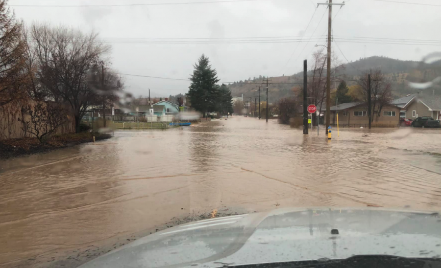
A local state of emergency has been declared in part of British Columbia’s eastern Fraser Valley where unrelenting rainfall caused flooding, mud and rock slides and the closure of highways to and from the southern Interior.
James Reinheller’s family home in Abbotsford is scheduled to be featured in House and Home magazine’s Christmas issue, but it was one of the first to be hit by a strong wave of water on Sunday as creeks overflowed in the neighbourhood.
Damage to some homes across the street was so severe they looked like they’d been hit by a vehicle, not water, he said.
Flood warnings and watches were issued on rivers and streams for areas from Merritt south to the United States border, the lower Fraser region and sections of southern Vancouver Island.
– With files from Canadian Press
(UPDATE: Nov. 15 @ 5:10 pm) – In this afternoon’s update on the flooding incidents occurring across the coast and Interior region, Minister Mike Farnworth explained that staff across the province continue to work as quickly and safely as possible.
Search and rescue teams are being deployed across the Lower Mainland.
Progress has been made and many people are being rescued by helicopter from the mudslides near Agassiz and Hope, the minister said.
The mudslide on Hwy 99 resulted in 50 people being trapped, but crews from Pemberton Search and Rescue managed to retrieve them and they are now being housed in Pemberton.
Twenty emergency operation centres have been activated across BC to respond to the current numbers of people being forced from their homes.
The mudslide near Haig, just north of Hope, has trapped many vehicles but exact numbers still need to be assessed as crews work to rescue those stranded in this area.
Environment Canada is forecasting that the rain is beginning to lighten in the Lower Mainland but strong winds are moving into the Vancouver and Victoria areas.
Rain is now expected to change to snow on the Coquihalla Summit and thunderstorms have been reported in Kelowna and can be anticipated to hit many other areas in the Interior.
There are four locations along highway 7 with debris and washouts on the roadways.
Near Haig, crews with the Ministry of Transportation have received the go ahead to begin removing debris from the highway but are just waiting for BCHydro to de-energize major power lines in the area.
As far as, the highway conditions, here are the latest updates:
-
Highway 1 remains closed south of Spences Bridge due to washout and debris flows.
-
Highway 5 continues to be closed between Hope and Merritt, as damage assessments are ongoing.
-
Highway 14, east of Sooke, has reopened to single lane, alternating traffic.
-
Highway 4, at Kennedy Lake, is also now open.
-
Highway 99, crews responded to the mudslide near Lillooet quickly opening it to the traffic stuck – but this highway remains closed with no estimated time of reopening.
-
Highway 12 is closed between Lyton and Lillooeet.
-
Highway 3 at Princeton also remains closed due to flooding.
For an update on the latest road closures, tune into DriveBC.
Highway 1, west of Revelstoke, also has mud on the road; the road remains open with crews on scene.
During the question period, Minister Farnworth explained that there have been no confirmed reports of fatalities at this time.
Farnworth also noted that, for people who are trapped, emergency personnel are working as quickly as they can to rescue people and clear the roads.
(UPDATE: Nov. 15 @ 12:12 pm): Efforts to rescue people trapped in dozens of vehicles on Hwy 7 are underway.
Pictures posted to social media show helicopters landing on the highway.
Minister of Public Safety Mike Farnworth said in a press conference earlier today that the people trapped in up to 100 vehicles on the highway were first responders' priority amid catastrophic flooding across the south of the province.
He said air rescue missions would be undertaken if necessary.
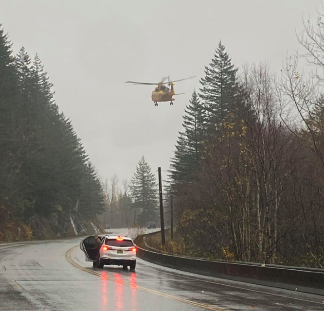
The Joint Rescue Coordination Centre said it is working the Aggassiz Fire, BCEHS, the RCMP and Canada Task Force One to evacuate the stranded motorists.
Roads across Southern British Columbia remain closed, with Vancouver now completely cut off from the rest of the province – and Canada – by land.
Hwy 1 has reopened between Sicamous and Revelstoke, however, though DriveBC has warned motorists that conditions are "constantly changing" in the area.
For a full list of road closures, head here.
Meanwhile, many BC residents have taken to social media to complain about cell service outages.
BC Hydro is also reporting outages affecting over a thousand customers.
Paula Cousins, the Ministry of Transportation’s representative for the Interior region, said the Hwy 5 corridor between Hope and Merritt remain closed Monday due to slides and falling rocks after 200 millimetres of rain since the weekend.
Heavy rain was expected to give way later Monday to storms that could uproot trees and cause more power outages in some areas after 16,000 customers, mostly in the eastern Fraser Valley, were without electricity on Sunday.
Armel Castellan, a meteorologist with Environment and Climate Change Canada, said wind gusts up to 90 kilometres an hour were expected for Victoria and much of the south coast and into the Interior.
"Definitely the atmospheric river will end today as it moves south, deeper into Washington state. That said, as that clearing happens, it’s going to be coming with a big shot of wind," he said.
A local state of emergency has been declared in part of British Columbia’s eastern Fraser Valley where unrelenting rainfall caused flooding, mud and rock slides and the closure of highways to and from the southern Interior.
Environment Canada said 225 millimetres of rain had deluged the community of Hope since the storm began Saturday and 180 millimetres had fallen around Agassiz and Chilliwack.
The District of Kent, which includes Agassiz, issued a local state of emergency after the landslides cut off Highway 7.
Flood warnings and watches were issued for areas from Merritt south to the United States border, the lower Fraser region and sections of southern Vancouver Island.
Rising rivers or landslides also prompted evacuation orders in Merritt, Agassiz, Abbotsford and in Princeton, where a dike burst Monday morning, forcing residents of about 200 properties from their homes.
About 7,000 people from the city of Merritt were ordered to leave as the Coldwater River quickly started overtaking roads and bridges.
"The floodwaters have now inundated two bridges across the Coldwater River, and floodwaters prevent access to the third," said the alert ordering the evacuation.
"High floodwaters have rendered the city’s wastewater treatment plant inoperable for an indefinite period. Continued habitation of the community without sanitary services presents risk of mass sewage backup and personal health risk."
The weather office said a further 50 millimetres of rain could drench the eastern Fraser Valley. Rain, snow and wind warnings covered most of the southern third of the province.
The City of Abbotsford opened a reception centre Sunday for residents who couldn’t get home or who were forced out because of mudslides or flooding at several locations.
The city said in a statement that the slides cut off several routes, and those who needed shelter or assistance could go to the Abbotsford Recreational Centre.
– With files from Canadian Press
(UPDATE: Nov. 15 @ 10:33 am): The entire city of Merritt has been evacuated due to flooding.
Mayor Linda Brown said Merritt "is and will remain strong" despite the catastrophic deluge.
"At this time, we need everyone to proceed in a calm and orderly manner to safe locations in nearby cities," she said.
"For your own safety, you must now leave Merritt, for the time being. Please, offer help to your friends, families, and neighbours, drive safely, and take care of yourselves. We will meet each other again, in our homes, where we belong.”
Merritt has a population of over 7,000 people.
The City said the flood waters have "inundated" two bridges and prevented access to the third.
It comes after the city's wastewater plant was rendered inoperable "for an indefinite period" due to flooding.
That means water cannot be used in homes in the city.
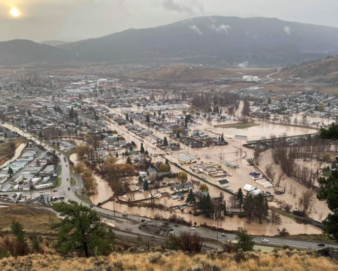
"Continued habitation of the community without sanitary services presents risk of mass sewage back-up and personal health risk," the City explained.
Residents who have nowhere else to stay have been told to head to either Kamloops or Kelowna.
If people have no reason to choose one city over the other, then residents with odd-numbered houses are advised to go to Kamloops and people with even-numbered houses are advised to head to Kelowna.
The reception centres are located at:
- Kamloops ESS Reception Centre is located at McArthur Island (1655 Island Parkway). Directions: Proceed North on Highway 5.
- Kelowna ESS Reception Centre is located at Parkinson Recreation Centre, 1700 Parkinson Way. Directions: Take highway 97C East to Kelowna.
Evacuees can register online ess.gov.bc.ca or call 1-800-585-9559 for more information.
A muster point has been created at the Nicola Valley Memorial Arena (2075 Mamette Ave), where the City will have bus evacuation services for those who can't leave independently.
(UPDATE: Nov. 15 @ 9:10 am): Minister of Public Safety Mike Farnworth has said flooding across Southern British Columbia has created a "dynamic" situation, with highways set to remain closed for an unknown length of time.
He said almost 2,000 people have been evacuated from Merritt, where the Coldwater River has burst its banks.
Residents remaining in the city have been told to stop using water because the wastewater treatment plant has failed.
The city warned: "Flushing a toilet or running a faucet at this time will result in it backing up into your home. Do NOT use any water further notice."
Farnworth said the entire community of Merritt could be evacuated if necessary, with support available for residents in Kamloops and Kelowna.
The minister also said there are between 80 and 100 vehicles trapped on Hwy 7 due to a landslide.
An air rescue mission is being considered, he added.
"They will be doing everything they can to ensure that they reach people who are trapped in their vehicles between those slides as quickly as possible," Farnworth said.
Geotechnical engineers are also trying to assess several highways severed by landslides, while some communities that issued evacuation alerts were sandbagging and bracing for potential flooding, he said.
Paula Cousins, the Ministry of Transportation’s representative for the Interior region, said the Highway 5 corridor between Hope and Merritt remain closed Monday due to slides and falling rocks after 200 millimetres of rain since the weekend.
Heavy rain was expected to give way later Monday to storms that could uproot trees and cause more power outages in some areas after 16,000 customers, mostly in the eastern Fraser Valley, were without electricity on Sunday.
Armel Castellan, a meteorologist with Environment and Climate Change Canada, said wind gusts up to 90 kilometres an hour were expected for Victoria and much of the south coast and into the Interior.
"Definitely the atmospheric river will end today as it moves south, deeper into Washington state. That said, as that clearing happens, it’s going to be coming with a big shot of wind," he said.
Farnworth said Hwy 1 is expected to be open again by about 5 pm, but could not give precise times for the reopening of other highways.
It comes as a local state of emergency has been declared in part of the eastern Fraser Valley where unrelenting rainfall caused flooding, mud and rock slides and the closure of highways to and from the southern Interior.
Environment Canada said 225 millimetres of rain had deluged the community of Hope since the storm began Saturday and 180 millimetres had fallen around Agassiz and Chilliwack.
The District of Kent, which includes Agassiz, issued a local state of emergency after landslides severed Hwy 7.
Maintenance crews said they were forced to wait until first light to confirm reports of trapped vehicles.
Flood warnings and watches were issued for areas from Merritt south to the United States border, the lower Fraser region and sections of southern Vancouver Island.
Rising rivers or landslides also prompted evacuation orders in Agassiz, Abbotsford and in Princeton, where a dike burst Monday morning, forcing residents of about 200 properties from their homes.
The weather office said a further 50 millimetres of rain could drench the eastern Fraser Valley. Rain, snow and wind warnings covered most of the southern third of the province.
The city of Abbotsford opened a reception centre Sunday for residents who couldn’t get home or who were forced out because of mudslides or flooding at several locations.
The city said in a statement that the slides cut off several routes, and those who needed shelter or assistance could go to the Abbotsford Recreational Centre.
Environment Canada said rain along the coast and snow in the eastern part of the province wasn’t expected to let up until sometime Monday. About 50 centimetres blanketed Highway 1 through the Rogers Pass and another 25 centimetres was expected.
"The snow level is expected to briefly rise to near Rogers Pass this afternoon, and snow may change to rain," said the weather office post. "However, rain will change back to snow this evening and additional accumulations are possible before the snow eases to scattered flurries late tonight."
Forecasters also warned of powerful winds over Victoria, Metro Vancouver and the Fraser Canyon later in the day — with gusts up to 90 km/h — which could possibly add to power outages that affected more than 16,000 customers, mainly in the eastern Fraser Valley, on Sunday night.
– With files from Canadian Press
(Original story: Nov. 15 @ 5:30 am): Several roads remain closed across British Columbia amid mud and rock slides caused by heavy rain.
The following highways remain closed:
-
Coquihalla between Hope and Merritt
-
Hwy 3 east of Princeton
-
Hwy 1 east of Revelstoke
-
Hwy 1 between Agassiz and Spences Bridge
-
Hwy 7 between Maple Ridge and Hope
For the full list of affected roads, click here.
A multi-vehicle incident was also reported along the Okanagan Connector last night, between Pennask Summit and Sunset Main Road.
In Merritt, meanwhile, an evacuation order has been issued after the Coldwater River broke its banks.
The city said it had 50 beds available early this morning, and is working on obtaining more.
“We are strongly encouraging residents to billet with friends and family in the community, as this is currently the safest option for evacuees,” the city explained.
In an update just after 4:30 am, the city told residents south of Coldwater Avenue and east of Voght Street to “evacuate immediately.”
The City of Abbotsford also opened a reception centre on Sunday for residents who couldn’t get home or who were evacuated because of mudslides or flooding at several locations.
The city said in a statement that mud or rock slides have cut off several routes, and that those who need shelter or assistance can go to the Abbotsford Recreational Centre.
Weather alerts remain in place for much of the south.
A so−called atmospheric river has hammered Southern BC, with rain along the coast or snow in the eastern part of the province.
Environment Canada said it was expected to let up on Monday.
Flooding on Sunday cut off access on Highway 11 to the Sumas border crossing into the United States.
Drivers were diverted to other Lower Mainland crossings until the possible reopening of the route on Monday.
– With files from Canadian Press


