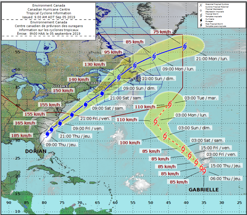
(Update: Sept. 5 @ 8:55 am): As the effects of Hurricane Dorian are being felt along the US southeast coast, Canadian forecasters say the storm system is expected to severely impact parts of the Atlantic provinces this weekend.
The Canadian Hurricane Centre says the most likely track projection brings Dorian south of the Maritimes on Saturday, pushing through eastern Nova Scotia late in the day.
The forecast calls for severe winds and rainfall to have major impacts for southeastern New Brunswick, Prince Edward Island, Nova Scotia, western Newfoundland and Quebec’s Lower North Shore, with a chance of a storm surge that may affect parts of Nova Scotia and Newfoundland.
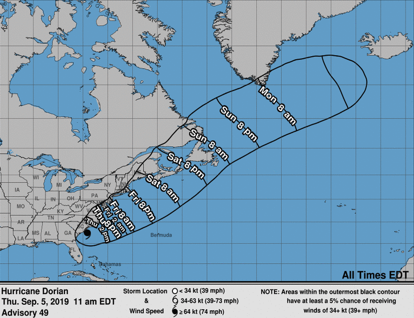
Most regions will experience some tropical storm force winds, with wind speeds that could reach hurricane force to the south of the forecast track and the possibility of hurricane force northwesterly winds behind the storm.
A Category 1 hurricane produces sustained wind speeds above 119 kilometres per hour. Tropical storm force winds exceed 63 kilometres per hour.
Forecasters are warning of potential tree damage in particular, which could lead to power outages.
Rainfall is expected to be significant, with the highest amounts likely for Nova Scotia and the Gulf of St. Lawrence region, with the possibility of as much as 100 millimetres to the north and west of Dorian.
– With files from the Canadian Press
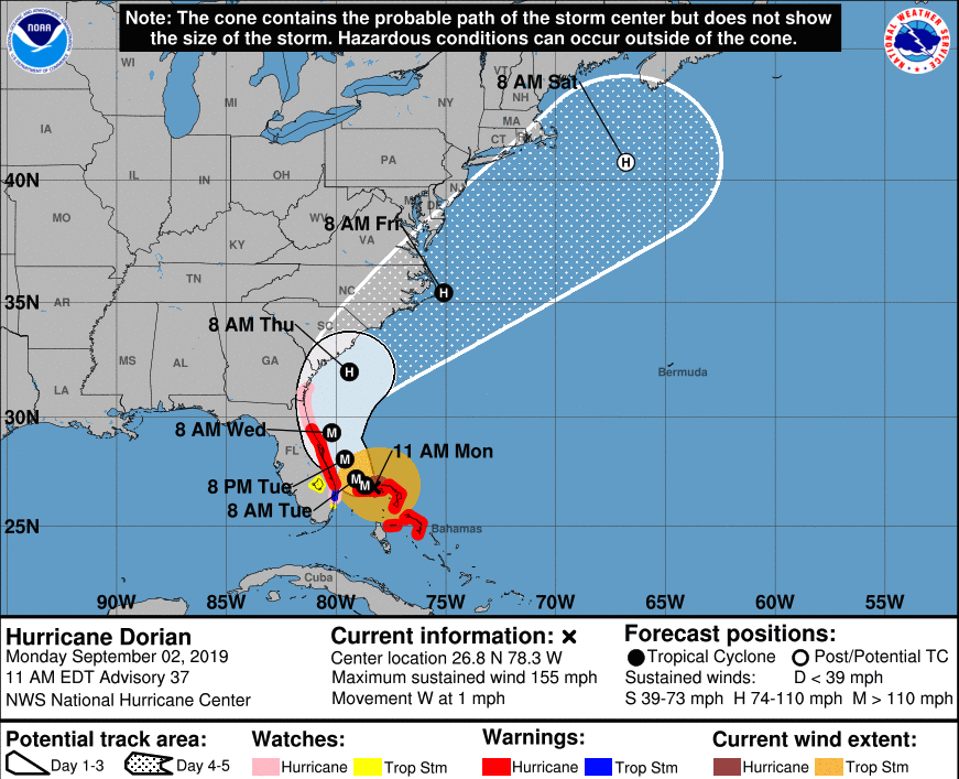
(Update: Sept. 2 @ 9:30 am): Hurricane Dorian has caused “unprecedented” devastation in the Bahamas, the country's leader has said.
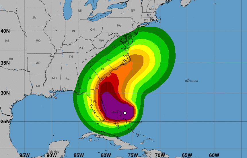
All eyes are now on the southeastern USA as the storm – relegated to category 4 but still considered extremely dangerous – lurches towards Florida and Georgia.
But Bahamas prime minister Hubert Minnis said the island of Grand Bahama is still feeling the impact of Dorian.
He added: “Based on reports out of Abaco, the devastation is unprecedented. Winds have decreased to 165MPH but Dorian remains an extremely dangerous storm.
“Our focus right now is rescue, recovery and prayer.”
Video coming out of the Atlantic Ocean nation show howling winds, flooded roads and battered homes.
The Red Cross estimates that around 13,000 homes have been destroyed or damaged in the storm.
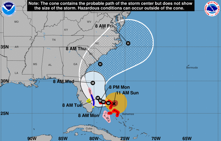
In the US, the National Hurricane Center (NHC) warned of life-threatening danger to residents of the states of Florida and Georgia.
There is also a strong risk in South and North Carolina.
Further north, the Mid-Atlantic American states are at risk of heavy rain and potential floods.
The effects of the storm are expected to be felt as far north as New Brunswick and Nova Scotia.
Florida, Georgia, North Carolina and South Carolina have all declared states of emergency.
“On this track, the core of extremely dangerous Hurricane Dorian will continue to pound Grand Bahama Island through much of today and tonight,” the NHC explained.
“The hurricane will then move dangerously close to the Florida east coast late tonight through Wednesday evening and then move dangerously close to the Georgia and South Carolina coasts on Wednesday night and Thursday.”
The storm is currently causing winds to blow at speeds as high as 250 km/h.
(Original story: Sept. 1 @ 8:30 am): Hurricane Dorian has been upgraded to a “catastrophic” category 5 storm as it surges towards the Bahamas and eastern United States.
The National Hurricane Center (NHC) in the US said this morning that Dorian is now the strongest hurricane in modern records to hit the northwestern Bahamas.
Residents of Grand Bahama have already started to evacuate.
The storm is expected to cause “life-threatening inundation,” the NHC said, with water levels rising by as much as 7 metres above normal.
“Large and destructive waves” will accompany devastatingly strong winds of up to 285 km/h.
There is also a warning of life-threatening flash floods as a consequence of intense rainfall.
Dorian is expected to hit the Bahamas later today and during Monday.
It is then predicted to move closer to Florida late on Monday and Tuesday.
“Some fluctuations in intensity are likely, but Dorian is expected to remain a powerful hurricane during the next few days,” the NHC explained.


