Due to recent unseasonal temperatures, many areas of the Southern Interior saw a rapid snowmelt, according to the latest data from the province.
In the latest snow survey and water supply bulletin, the province says some parts of the Interior saw snowmelt rates up to five centimeters per day.
As a result of that rapid snowmelt last week, the province says the snow basin numbers do not represent the current conditions, which were taken on May 1.
“The unseasonably warm weather continued for the first week of May, especially for the South Interior,” says the province in the bulletin issued on Tuesday.
“The provincial snow pack has rapidly melted since May 1st. Another strong high-pressure ridge is forecast to impact the province this weekend (May 13-14) continuing the rapid snowmelt.”
Much of the snowmelt across the Interior was delayed until the end of April but that could change rapidly again because by Sunday, Kelowna and Penticton are expected to see a high of 32ºC while Kamloops is forecast to hit 34ºC.
Just eight days ago, the Okanagan had a snowpack 144% above normal levels while the Boundary region’s levels were 129% above normal.
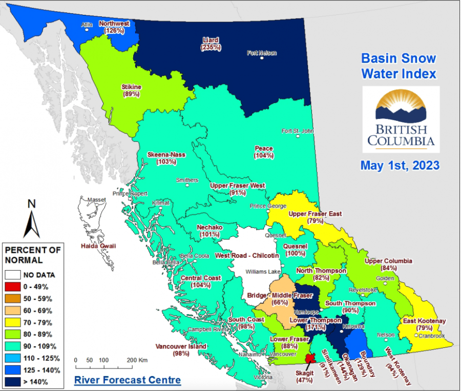
These two snowpacks have consistently been some of the highest in the province, according to the Mar. 9 and April 12 snowpack numbers.
The Lower Thompson and Nicola snow packs were also high and recorded at 171% and 150% above normal, respectively. The North and South Thompson snowpacks were much lower with levels at 82% and 90% below normal.
Currently, the Liard snowpack in northern BC has the highest level in the province and is 235% above normal levels. Meanwhile, the Bridge basin, a sub-basin in the Middle Fraser, has the lowest number in the province at 66% below normal.
The province stressed the fact that the May 1 numbers were not representative of the existing conditions and confirmed more accurate data would be provided in the Friday, May 19 bulletin.
After that, one more bulletin will be released on Thursday, June 8 with the final bulletin being issued on Monday, June 19.
Thumbnail photo credit: Canadian Press


