The absolute warmest temperature Kelownians can expect over the next seven days is -7°C, but most of next week will be a whole lot colder.
Environment Canada is predicting Kelowna’s freezing snap will not only continue, but deepen, over the next seven days with temperatures dropping as low as -17°C.
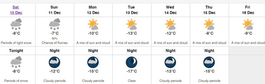
Today, temperatures will likely remain steady at about -8°C, with cloudy skies all day and about 2 to 4 centimetres of snow coming down.
Those clouds and snowy periods will continue into tomorrow morning, when the temperature will climb to what Environment Canada is predicting to be the weekly high of -7°C.
From there, Monday will see some sun in the sky, but the mercury will dip to as low as -15°C.
For the rest of the week, Environment Canada says the sky will remain partly cloudy and temperatures will fluctuate anywhere from -8°C to -17°C. Temperatures for this time of year normally hover around 0 to -4°C.
The agency isn't predicting any more snow during that time.
Meanwhile, Environment Canada says sunrise today is at 7:45 a.m., and sunset will be a 3:37 p.m.
The light lingers for a while before and after the sun leaves the sky, but that less than 7-hour window doesn’t leave much daylight during these cold days.


