The April 1 snowpack numbers are in and they can be summed up by one word – concerning.
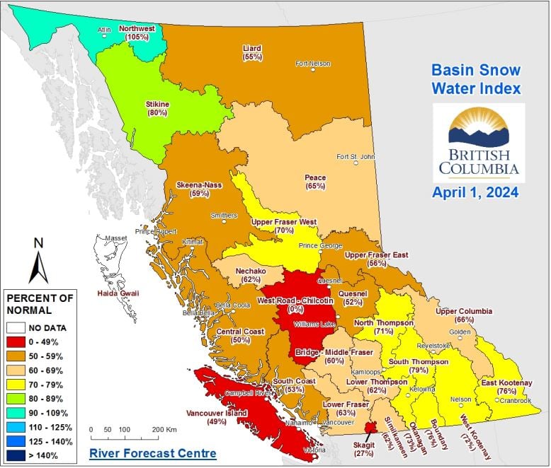
The latest data from the BC River Forecast Centre (BCRFC) says the provincial snowpack is “extremely low,” averaging 63% of normal across British Columbia.
“It is the lowest snowpack on record since 1970, at least, for the province,” notes the BCRFC’s newest Snow Survey and Water Supply Bulletin.
It’s a continuation of the trend we’ve seen throughout the first three months of 2024, but the difference is that there is little to no time left for the snowpacks to increase.
Bleak snowpack numbers in January, February and March could at least lean on the fact that winter was not over and there was still potential for snow to fall at higher elevations.
By April 1, however, the Province says that 95% of the seasonal snowpack has typically accumulated.
While this all means that there’s a lesser chance of spring freshet flooding, there are grave drought and wildfire concerns for BC moving forward.
“The experts at the BCRFC tell us these low levels and the impacts of year-over-year drought are creating significantly higher drought risk for this spring and summer,” said Nathan Cullen, Minister of Water, Land and Resource Stewardship.
“We know this is concerning news. Communities around BC experienced serious drought conditions last summer. It fuelled the worst wildfire season ever, harmed fish and wildlife, and affected farmers, ranchers, First Nations and industry.”
A month ago, there were only a handful of snow basins that had more than 80% of their typical snowpack for March 1.
Fast forward 31 days and that handful has diminished to just the Northwest and Stikine snow basins at 105% and 80% respectively.
Much of the Province is staring down numbers between 50-70%, although things look slightly more optimistic around the Thompson-Okanagan.
The North Thompson and South Thompson snow basins sit at 71% and 79% respectively, while the Okanagan snow basin is at 73%.
Bordering these regions are the 62% Lower Thompson basin, the 62% Similkameen basin and the 76% Boundary basin, while the two Kootenay snow basins are at 72% and 76%.
Cullen says the Province will “continue to take strong action” to help food producers, farmers and ranchers, as well as strengthen BC’s resilience to drought.
To see the BCRFC’s April 1 snowpack report for yourself, click this link.


