**Coverage of the McDougall Creek wildfire will continue at this link on Saturday.**
(UPDATE: Aug. 18 @ 9:30 pm) - After briefly rescinding the evacuation order for the Smith Creek area Friday evening, Central Okanagan Emergency Operations (CORD) has officially told residents in that area to leave.
All the information below in the 7:25 pm update is now update to date as of 9:30 pm.
(UPDATE: Aug. 18 @ 7:25 pm) - Central Okanagan Emergency Management (CORD) has specified its most recent expansion of evacuation orders in West Kelowna.
It includes properties on Westbank First Nation IR#9, which means the entire Shannon Lake area is now under an evacuated order.
The following properties are affected:
- All properties located on Westbank First Nation IR#9 North of Highway 97 between Daimler Drive and Grizzly Road
- All properties located on Westbank First Nation IR#9 North of Old Okanagan Highway between Grizzly Road and Shannon Lake Road
- Specific additions include: 3206, 3210, 3230, 3270 Shannon Lake Road
As mentioned in the update below, it essentially means that all of West Kelowna north of Hwy 97, with the exception of Glenrosa and the city centre area, has been told to leave.
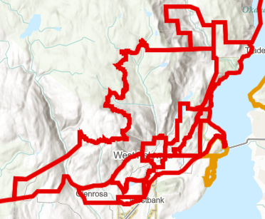
Click this link to view the entire maps of currently evacuation orders and alerts.
(UPDATE: Aug. 18 @ 7:05 pm) - The BC Wildfire Service now estimates the McDougall Creek wildfire to be 10,500 hectares in size.
It has grown around 10 times in size over the past 24 hours.
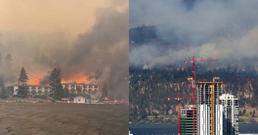
After claiming dozens of homes in Traders Cove and nearby areas on Thursday night, the fire continued its tear through structures in West Kelowna again on Friday.
That includes Lake Okanagan Resort, which burned down this morning, and several other properties along Westside Road.
Multiple properties along Scott Crescent and other nearby roads in the Diamond View Estates area, above Sailview Bay, also reportedly burned down on Friday.
While the cause of the fire is still unknown, Kelowna Fire Chief Travis Whiting said this morning spotting from the McDougall Creek wildfire is believed to be the cause of the fires on the Kelowna side of the lake.
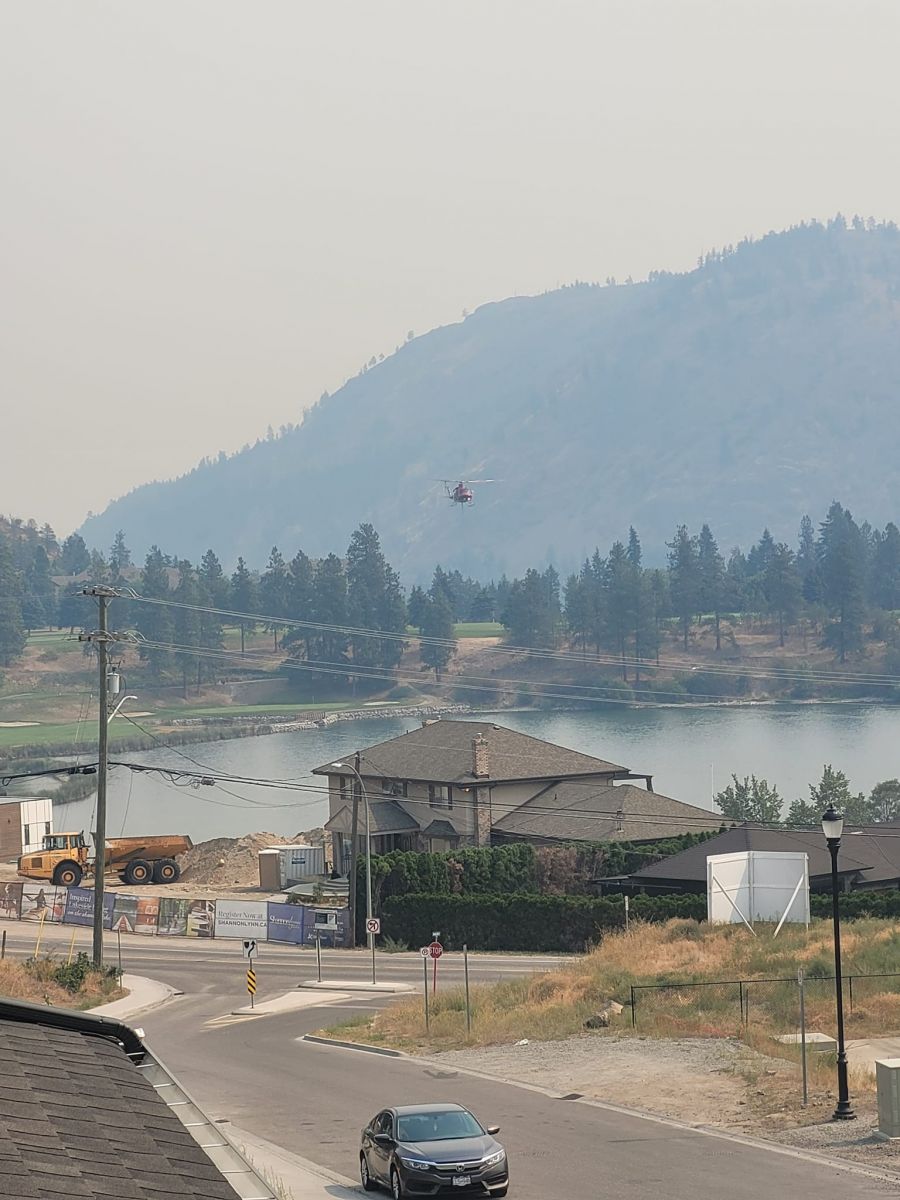
Dozens of firefighters from the BCWS, local fire halls and departments across the province are on the ground doing their best to contain the monster blaze.
They're being supported in the air by helicopters and air tankers, but they will soon have to ground for the evening.
Evacuation orders and alerts have continued to quickly climb in numbers throughout the day and you can find a map of the evacuation areas here.
The majority of West Kelowna north of Hwy 97, with the exception of Glenrosa and the city centre, is under an evacuation order.
Late Friday afternoon, an evacuation alert was put in place for Westbank First Nation reserve #10 and the Casa Loma area due to a new spot fire in the Campbell Road area, near the west end of the Bennett Bridge and Shelter Bay Marina.
(UPDATE: Aug. 18 @ 5:45 pm) – New evacuation alerts have been issued for properties on Westbank First Nation (WFN) reserve #10 and in the Casa Loma area.
The alerts come less than an hour after orders were issued for properties on reserve lands and just after the Central Okanagan Emergency Operations Centre updated its map for the Lakeview Heights area
Those properties under evacuation alert on WFN lands include:
- ABEL PL
- ESSEN RD
- ABEL ST
- HIGHWAY 97
- ALEXANDER PL
- HIGHWAY 97 S
- BAYVIEW CRT
- MANUEL RD
- CAMPBELL PL
- MICHELLE CRES
- CAMPBELL RD
- SNEENA RD
- DERRICKSON PL
- TOMAT AVE
Properties under evacuation alert in the Casa Loma and Lakeview Heights area include:
- ALICE RD
- BENEDICK RD
- CAMPBELL RD
- CASA GRANDE DR
- CASA LOMA RD
- CASA PALMERO DR
- CASA RIO DR
- LUCINDE RD
- ZDRALEK COVE
Residents can refer to the interactive map on cordemergency.ca to search by street address to determine if they are in the ALERT or ORDER area.
Residents under the alert must be ready to leave their homes at a moment’s notice, be prepared to be away from their homes for an extended period of time, make arrangements for pets and pack essential items such as medicines and important documents.
(UPDATE: Aug. 18 @ 4:50 pm) – A new evacuation order has been issued for Westbank First Nation reserve #10.
The Central Okanagan Emergency Operations centre issued the evacuation order at 4:40 pm.
This includes properties on all the following roads on reserve lands:
- BEACH VIEW LANE
- LINDLEY DR
- BEAR CREEK RD
- LINDLEY RD
- BROOKSIDE PL
- MARINA WAY
- CAWSTON AVE
- MARINA WAY E
- CREST RIDGE LANE
- NANCEE WAY
- FERRY WHARF RD
- NANCEE WAY CRT
- HARBOUR GREEN RD
- OKANAGAN LAKE
- HARBOUR POINTE LANE
- OLD FERRY WHARF RD
- HARBOUR VIEW BLVD
- ROSIE DR
- HARBOUR VIEW CRES
- SOOKINCHUTE CRT
- HIGHWAY 97
- SPLAND RD
- HIGHWAY 97 S
- VIEWPOINT CRES
- HIGHWAY 97 S
- VIEWPOINT DR
- HORIZON DR
- WATERS EDGE LANE
- KATHERINE RD
- WESTSIDE RD
- LAKE BREEZE RD
- WESTSIDE RD S
- LAKE VISTA DR
- LAKE VISTA RD
Westbank First Nation has issued a due not consume order for the reserved area because they are removing chlorine toners to ensure the safety of first responders and the general public.
This will result in no ability for anyone to consume the water on this system as there will be no treatment process moving forward.
“The pump house will be guarded in hopes that we might be able to save the structure but the largest risk is trying to be removed by staff before the fire arrives,” says a release from WFN utilities staff.
“Raw water will still be available to help with fire protection but this water is not consumable for humans.”
New evacuation alerts have been issued for the West Kelowna Business Park, Upper Glenrosa and Lakeview Heights as well.
The new alert area in the business parks covers an area north of Stevens Road and between Dominion Road and just west of Horizon Drive.
This includes McDougall Road, Stevens Road, Sussex Road and Somerset Road.
Posts on Twitter show a new spot fire has started beside Valhalla helicopters this afternoon.
Click here to view the Central Okanagan Emergency Operations map to see if your property is within any of these evacuation alert areas.
Anyone under an evacuation alert must be ready to leave at a moment’s notice.
(UPDATE: Aug. 18 @ 2:10 pm) – The latest round of evacuation orders for West Kelowna includes Shannon Lake, as well as more properties up Westside Road.
An official statement regarding the Shannon Lake evacuations has not been released, but KelownaNow has heard from several residents who say they've been told to leave.
The Central Okanagan Emergency Operations (CORD) evacuation map does now include all properties in the Shannon Lake neighbourhood, including the Tallus Ridge development.
Helicopters are currently using Shannon Lake to bucket water for the fire.
"Properties north of Terrace Mountain Road along Westside including La Casa up to and including Fintry Provincial Park must evacuate north on Westside Road," adds a CORD release.
Tactical evacuations of those properties is underway and includes:
- BARCELONA DR E
- DELTA RD
- DUNWATERS RD
- FAIRBRIDGE RD
- FINTRY DELTA RD
- FINTRY ESTATES
- GRAY RD
- KELLY PL
- LA PALMA LOOP
- MADRID WAY
- MARBELLA LOOP
- MORDEN RD
- MUIR RD
- SANTE FE WAY
- SANTIAGO LOOP
- SHALAL RD
- SHORTS RD
- SHORTS CREEK
- TERAZONA DR
- TOLEDO DR
- VALENCIA WAY
- VERONA LOOP
- WESTSIDE RD
- WESTSIDE RD N
The McDougall Creek wildfire remains estimated at 6,800 hectares, although it is likely higher since BC Wildfire Service hasn't updated that estimate since early this morning.
(UPDATE: Aug. 18 @ 11:45 am) - Officials spoke to the media this morning and that included a somber, emotional West Kelowna Fire Chief.
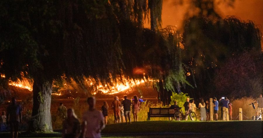
Jason Brolund described Thursday night's efforts as being "like 100 years of firefighting, all at once, all in one night."
He called it a devastating night and one of the toughest of his career, as well as "one of the most challenging nights of firefighting in our history."
Those comments came less than 48 hours after the Central Okanagan marked the 20-year anniversary of the 2003 Okanagan Mountain Park wildfire.
Brolund did not beat around the bush when he said that evacuees will not be going home soon, noting that homes were burning as he spoke.
From the KelownaNow office high up Landmark 6, it has appeared that homes along the hill above Sailview Bay have burned today, although it is difficult to confirm.
A photo has been making the rounds online of Lake Okanagan Resort fully engulfed in flames this morning.
Officials could not confirm how many homes burned in West Kelowna Thursday night, although sources have told KelownaNow the number was around 80.
And while Brolund admitted that a "significant number" of structures were lost, and promised firefighters will do everything they can to improve that going forward, he added that the number of homes saved in the West Kelowna Estates area were "too numerous to list."
Crews have managed to successfully protect the $75-million Rose Valley Water Treatment, the Rose Valley Dam and the fire hall and elementary school in the area at this time.
However, their work is far from over. "It's not done," noted Brolund.
He said the winds today will be stronger than the were Thursday and it will be "another scary night. People can expect to see the glow of fire once again.
Brolund noted that his team has submitted a resource request to seriously bolster numbers as soon as possible.
(UPDATE: Aug. 18 @ 9:10 am) - Central Okanagan Emergency Services (CORD) has made a slight expansion of McDougall Creek wildfire evacuation orders.
Properties north of Nahun, but not including La Casa, have been told to leave the area immediately.
"It’s critical that all residents evacuate for their safety and the safety of first responders in the area," notes a CORD release.
These residents, if they haven't already, should head north to Vernon to the reception centre at Kal Tire Place (3445 43rd Ave.). They should also register online as evacuees if they haven't already.
While the new orders are for the northeast flank of the fire, activity is visibly ramping up in the Rose Valley area, which includes flames visible from across the lake.
There is air support attacking the blaze and the BCWS website says 21 ground personnel are assigned to the fire, but it's not clear if that's the most up-to-date number.
(Original story: Aug. 18 @ 8:05 am) - It comes as no surprise with the fire activity that was witnessed Thursday night and into the early hours of Friday morning, but the McDougall Creek wildfire has grown exponentially.
The BC Wildfire Service now estimates the fire at 6,800 hectares in size, more than six times the 1,100-hectare estimate from Thursday afternoon.
Central Okanagan Emergency Operations confirmed the fire consumed several structures as it spread late Thursday evening.
KelownaNow has learned that the current estimate is 80 homes lost in West Kelowna, but officials are expected to provide a more definite number around 10 am after an assessment this morning.
A Rose Valley resident shared photos of their security camera on Sunview Drive, facing northwest around 250 metres from the Rose Valley Regional Park parking lot, which showed flames in the trees.
The images suggest that the fire is already in the popular regional park and not far from Westlake Road, while others corroborated reports that the fire crested the hill and now hovers over Rose Valley Elementary.
According to Central Okanagan Emergency Operations (CORD), 2,462 properties are under evacuation order and 4,801 properties are under evacuation alert in West Kelowna.
KelownaNow will update this story throughout the day as the situation develops. Click this link to see our coverage of the McDougall Creek wildfire on Thursday and into the early-morning hours of Friday.


