Account Login/Registration

Access KelownaNow using your Facebook account, or by entering your information below.


Facebook


OR


Register

Privacy Policy

Expect the snow to continue and get wetter as the day goes on

The Central Okanagan woke up to snow again on Thursday morning.

It’s been falling steadily for most of the night and will continue that way throughout the day, but it won’t pile up too much.

Environment Canada calls for periods of snow all day long, but it’ll only amount to between 2 and 4 cm on the ground.

<who>Photo Credit: Environment Canada

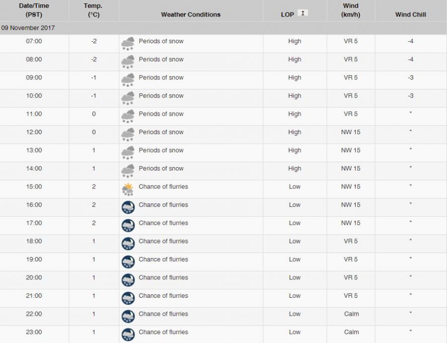
As the temperature warms up throughout the day, the snow will turn into wet flurries in the early afternoon.

It’ll get up to a high of 2°C around 3 p.m., which is the forecasted high for the day.

The precipitation will move out of the area overnight between Thursday and Friday and it’s expected to be a dry long weekend for the most part.

<who>Photo Credit: Environment Canada

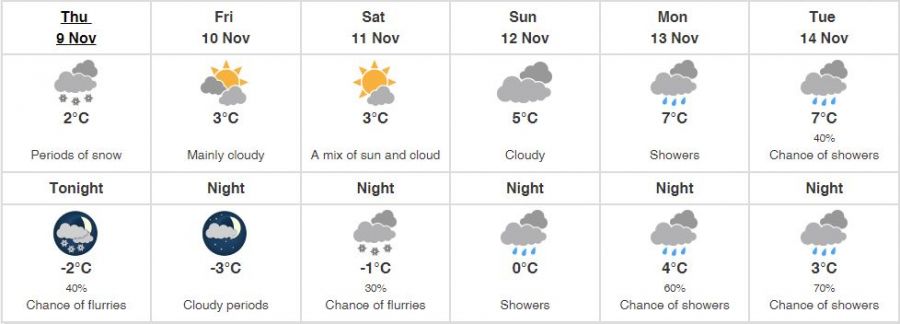
Rain is supposed to come back into the Okanagan Valley on Monday, but there’s no chance it will turn to snow with a low of 4°C.

Give your commute an extra few minutes on Thursday and if you’re out enjoying the snowfall, tag your pictures with #KelownaNow!


If you get value from KelownaNow and believe local independent media is important to our community we ask that you please consider subscribing to our daily newsletter.

If you appreciate what we do, we ask that you consider supporting our local independent news platform.


Send your comments, news tips, typos, letter to the editor, photos and videos to news@kelownanow.com.


weather-icon
Fri
16℃

weather-icon
Sat
17℃

weather-icon
Sun
14℃

weather-icon
Mon
13℃

weather-icon
Tue
15℃

weather-icon
Wed
18℃

current feed webcam icon

Recent Livestream


Top Stories

Follow Us

Follow us on Instagram Follow us on Twitter Like us on Facebook Follow us on Linkedin Follow us on Youtube Listen on Soundcloud Follow Our TikTok Feed Follow Our RSS Follow Our pinterest Feed
Follow Our Newsletter
Privacy Policy