Weather forecasts are often based on confidence. This week’s forecast confidence is certainly higher that most weeks, based on the type of upper air pattern we have. Go ahead and make those camping or boating plans over the next few days - it’s going to be warm and sunny - guaranteed!
It’s not often you will hear a meteorologist guarantee a forecast several days in advance because at times, we can only predict the next couple of days with confidence when it comes to certain weather patterns. I would never bet any money on weather during occasions when we are expecting multiple weather systems to move into our valley. However, our current type of a weather pattern - a blocking pattern called the Omega Block - gives meteorologists an unusually high level of confidence to predict the forecast almost a week in advance.
The Omega Block is a specific pattern that weather forecasters look for on the 500mb chart. This chart depicts what is happening at about 5000m above the surface of the earth. To some, this might just look like some kind of a tie-dyed painting, but to a trained weather eye, this blocking pattern means Southern BC will be getting a stretch of not only warm, but also dry weather.
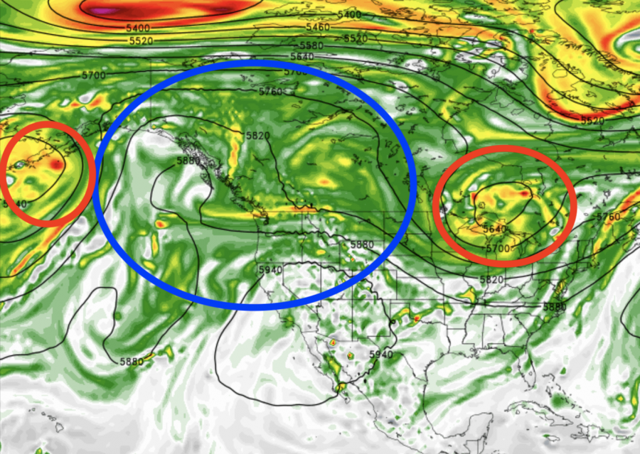
What you are looking at is an upper ridge over BC (I’ve circled it in blue) between two upper troughs (I’ve circled those in red). Whenever we see this pattern on the 500mb chart, we know that Okanagan beach lovers and sun worshippers will be happy.
When blocking patterns occur, we see no weather systems moving into BC and we can expect a prolonged period of stable and dry weather as the stationary upper ridge maintains high pressure over our region. Often with this type of a pattern, the BC Southern Interior will see a week of sun and temperatures near 30C.
Unfortunately this weather pattern is also conducive to smoke getting trapped in the valley because of little vertical air movement, so fingers crossed for no more wildfires this week.
Enjoy the Okanagan sun and don’t forget to the sunscreen and stay hydrated!


